1990s Maps of Leadville, Colorado
Explore 2 historic maps of Leadville from the 1990s. These maps offer a rare glimpse into what life looked like during the 1990s — showing old roads, neighborhoods, homes, and landmarks that have changed or disappeared over time.
Whether you're researching your family's past, planning a metal detecting trip, or studying how Leadville's landscape evolved across the 1990s, these high-resolution maps are a powerful tool for exploring the history of this region.
- Focus on a specific era: All maps on this page are from the 1990s, giving you a focused view of this time period.
- See what’s changed: Compare century-old streets, trails, and buildings to today's modern landscape using overlays and satellite layers.
- Research with precision: Use these maps for genealogy, historical research, land use analysis, or educational projects.
- View, download, or print: Maps are fully viewable online in high resolution, and can be downloaded or printed for your own records.
Start exploring Leadville's history through authentic maps from the 1990s. This is your window into the past.
Leadville, CO maps
(2)- 1994 Map of Leadville South, 1998 Print
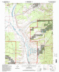 1994 Leadville South1998 Print · USGSLeadville and its southern mining districts are captured in the mid-nineties, showing a landscape defined by silver-mining history and high-altitude industry. Researchers can trace the heritage of the gulches through sites like the Badger State Mine, St Joseph Cem, and the old settlement at Oro.
 - 1994 Map of Leadville North, 1998 Print
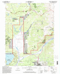 1994 Leadville North1998 Print · USGSThe Colorado high country near the Continental Divide is captured here in the mid-1990s as the historic mining district meets modern recreation. Genealogists and historians can trace the Evergreen Cem, old rail lines at Leadville Junction, and storied mines like the Matchless Mine.
End of results
Showing maps 1-2 of 2
Top cities near Leadville
Frequently asked questions
- What are the different types of historical maps available for Leadville?
- What is the oldest map of Leadville?
- Where can I purchase historical maps of Leadville for my home or office?
- Where can I download high-res historical maps of Leadville?
- Are there historical topographic maps available for Leadville?
- Is there historical aerial imagery available for Leadville?
- Where are historical maps of Leadville sourced from?