2020s Maps of Red Feather Lakes, Colorado
Explore 3 historic maps of Red Feather Lakes from the 2020s. These maps offer a rare glimpse into what life looked like during the 2020s — showing old roads, neighborhoods, homes, and landmarks that have changed or disappeared over time.
Whether you're researching your family's past, planning a metal detecting trip, or studying how Red Feather Lakes's landscape evolved across the 2020s, these high-resolution maps are a powerful tool for exploring the history of this region.
- Focus on a specific era: All maps on this page are from the 2020s, giving you a focused view of this time period.
- See what’s changed: Compare century-old streets, trails, and buildings to today's modern landscape using overlays and satellite layers.
- Research with precision: Use these maps for genealogy, historical research, land use analysis, or educational projects.
- View, download, or print: Maps are fully viewable online in high resolution, and can be downloaded or printed for your own records.
Start exploring Red Feather Lakes's history through authentic maps from the 2020s. This is your window into the past.
Red Feather Lakes, CO maps
(3)- 2022 Map of Red Feather Lakes, 2022 Print
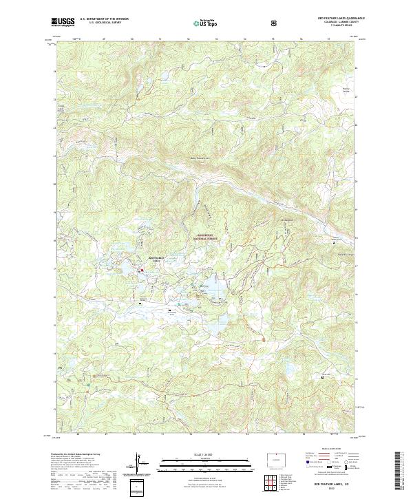 2022 Red Feather Lakes2022 Print · USGSRed Feather Lakes and the surrounding Roosevelt National Forest appear here in a recent survey of this high Colorado plateau. Researchers can locate the Levi Yockey Grave, the Jewett Family Cem, and historic water routes like the S Pine Supply Ditch.
 - 2022 Map of Haystack Gulch, 2022 Print
 2022 Haystack Gulch2022 Print · USGSThe Larimer County backcountry is revealed in this modern survey of the Front Range as it appeared in the early twenty-first century. Outdoor researchers can trace backcountry routes through Roosevelt National Forest and locate specific peaks like Sheep Mtn and Haystack Butte.
 - 2022 Map of South Bald Mountain, 2022 Print
 2022 South Bald Mountain2022 Print · USGSLarimer County's high country is captured here in the early 2020s, showing the intersection of wild forest lands and mountain residential enclaves. Researchers can trace family sites at Black Mountain Ranch Cemetery or locate remote properties near Crystal Lakes Airport and South Bald Mtn.
End of results
Showing maps 1-3 of 3
Frequently asked questions
- What are the different types of historical maps available for Red Feather Lakes?
- What is the oldest map of Red Feather Lakes?
- Where can I purchase historical maps of Red Feather Lakes for my home or office?
- Where can I download high-res historical maps of Red Feather Lakes?
- Are there historical topographic maps available for Red Feather Lakes?
- Is there historical aerial imagery available for Red Feather Lakes?
- Where are historical maps of Red Feather Lakes sourced from?