1960s Maps of Red Feather Lakes, Colorado
Explore 6 historic maps of Red Feather Lakes from the 1960s. These maps offer a rare glimpse into what life looked like during the 1960s — showing old roads, neighborhoods, homes, and landmarks that have changed or disappeared over time.
Whether you're researching your family's past, planning a metal detecting trip, or studying how Red Feather Lakes's landscape evolved across the 1960s, these high-resolution maps are a powerful tool for exploring the history of this region.
- Focus on a specific era: All maps on this page are from the 1960s, giving you a focused view of this time period.
- See what’s changed: Compare century-old streets, trails, and buildings to today's modern landscape using overlays and satellite layers.
- Research with precision: Use these maps for genealogy, historical research, land use analysis, or educational projects.
- View, download, or print: Maps are fully viewable online in high resolution, and can be downloaded or printed for your own records.
Start exploring Red Feather Lakes's history through authentic maps from the 1960s. This is your window into the past.
Red Feather Lakes, CO maps
(6)- 1960 Map of Haystack Gulch, 1962 Print
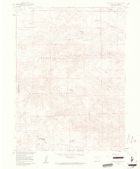 1960 Haystack Gulch1962 Print · USGSLarimer County high country in the early sixties centers on the rugged drainage of the Rabbit Creek forks. Trace old family sites and rural landmarks like Log Cabin, the Lone Pine Sch, and Stuart Hole along the Red Feather Lakes Road.4 unique versions available
 - 1961 Map of Greeley
 1961 Greeley1961 Print · USGSNorthern Colorado's transition from high mountain peaks to irrigated plains is captured here just as the post-war population boom reached the Front Range. Researchers can trace early water infrastructure and rail lines like the Great Western RR connecting sugar beet hubs from Fort Collins to Greeley.
 - 1964 Map of Greeley
 1964 Greeley1964 Print · USGSThe Front Range corridor and high peaks of the Rockies appear here in the mid-1960s, showing the intersection of mountain wilderness and plains agriculture. Trace the rail routes of the Great Western RR or locate landmarks like Longs Peak and Horsetooth Reservoir.
 - 1965 Map of Greeley
 1965 Greeley1965 Print · USGSNorthern Colorado in the mid-sixties shows a landscape defined by high mountain summits and the growing irrigation networks of the plains. Genealogists and historians can trace rail-side towns like Wellington or follow the early tracks of the Union Pacific Railroad past Longs Peak.
 - 1967 Map of South Bald Mountain, 1971 Print
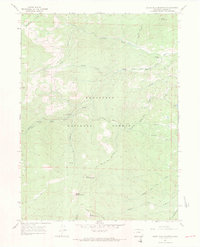 1967 South Bald Mountain1971 Print · USGSHigh in the Colorado Front Range during the mid-sixties, this area of the Roosevelt National Forest shows a landscape defined by ranching and mountain peaks. Researchers can trace the water history of Mitchell Ditch or locate Black Mtn Ranch and the Prospect near Deadman Hill.3 unique versions available
 - 1967 Map of Red Feather Lakes, 1971 Print
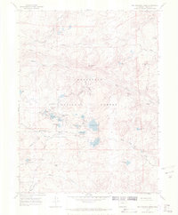 1967 Red Feather Lakes1971 Print · USGSIn the late 1960s, the high-altitude community of Red Feather Lakes was a established hub for mountain recreation and ranching. Genealogists and hikers can trace the footprints of Maxwell Ranch or locate local landmarks like Chapel In the Pines and Many Thunders Mountain.2 unique versions available
End of results
Showing maps 1-6 of 6
Frequently asked questions
- What are the different types of historical maps available for Red Feather Lakes?
- What is the oldest map of Red Feather Lakes?
- Where can I purchase historical maps of Red Feather Lakes for my home or office?
- Where can I download high-res historical maps of Red Feather Lakes?
- Are there historical topographic maps available for Red Feather Lakes?
- Is there historical aerial imagery available for Red Feather Lakes?
- Where are historical maps of Red Feather Lakes sourced from?