1980s Maps of Wellington, Colorado
Explore 2 historic maps of Wellington from the 1980s. These maps offer a rare glimpse into what life looked like during the 1980s — showing old roads, neighborhoods, homes, and landmarks that have changed or disappeared over time.
Whether you're researching your family's past, planning a metal detecting trip, or studying how Wellington's landscape evolved across the 1980s, these high-resolution maps are a powerful tool for exploring the history of this region.
- Focus on a specific era: All maps on this page are from the 1980s, giving you a focused view of this time period.
- See what’s changed: Compare century-old streets, trails, and buildings to today's modern landscape using overlays and satellite layers.
- Research with precision: Use these maps for genealogy, historical research, land use analysis, or educational projects.
- View, download, or print: Maps are fully viewable online in high resolution, and can be downloaded or printed for your own records.
Start exploring Wellington's history through authentic maps from the 1980s. This is your window into the past.
Wellington, CO maps
(2)- 1980 Map of Fort Collins, 1981 Print
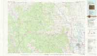 1980 Fort Collins1981 Print · USGSThe Front Range and high Rockies meet in Larimer County during the early 1980s. Local researchers can trace the growth of Fort Collins, the irrigation network around Wellington, and high-country outposts like Red Feather Lakes or the scenic canyon settlement of Mishawaka.
 - 1982 Map of Eaton
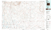 1982 Eaton1982 Print · USGSNorthern Colorado and the Wyoming borderlands are captured here in the early eighties, showcasing a vast agricultural and rail landscape. Trace family roots and vanished infrastructure through Chalk Bluffs, the Great Western railroad, and Keota.2 unique versions available
End of results
Showing maps 1-2 of 2
Top cities near Wellington
- Fort Collins historical maps
- Greeley historical maps
- Windsor historical maps
- Severance historical maps
- Nunn historical maps
- Timnath historical maps
Top neighborhoods of Wellington
- Wellington historical maps
- Wellington Village Condominiums historical maps
- Park Meadows historical maps
Frequently asked questions
- What are the different types of historical maps available for Wellington?
- What is the oldest map of Wellington?
- Where can I purchase historical maps of Wellington for my home or office?
- Where can I download high-res historical maps of Wellington?
- Are there historical topographic maps available for Wellington?
- Is there historical aerial imagery available for Wellington?
- Where are historical maps of Wellington sourced from?