1900s (20th Century) Maps of Delhi, Colorado
Explore 9 historic maps of Delhi from the 1900s (20th Century). These maps offer a rare glimpse into what life looked like during the 1900s — showing old roads, neighborhoods, homes, and landmarks that have changed or disappeared over time.
Whether you're researching your family's past, planning a metal detecting trip, or studying how Delhi's landscape evolved across the 1900s, these high-resolution maps are a powerful tool for exploring the history of this region.
- Focus on a specific era: All maps on this page are from the 1900s, giving you a focused view of this time period.
- See what’s changed: Compare century-old streets, trails, and buildings to today's modern landscape using overlays and satellite layers.
- Research with precision: Use these maps for genealogy, historical research, land use analysis, or educational projects.
- View, download, or print: Maps are fully viewable online in high resolution, and can be downloaded or printed for your own records.
Start exploring Delhi's history through authentic maps from the 1900s. This is your window into the past.
Delhi, CO maps
(9)- 1954 Map of Trinidad, 1963 Print
 1954 Trinidad1963 Print · USGSSouthern Colorado is captured here during the mid-fifties, showing the vital rail-and-river connections between the San Luis Valley and the eastern foothills. Researchers can trace the Denver and Rio Grande Western line and locate rural landmarks like Malachite School and San Luis.2 unique versions available
 - 1955 Map of Trinidad, 1976 Print
 1955 Trinidad1976 Print · USGSSouthern Colorado during the mid-fifties is defined by the high-altitude agriculture of the San Luis Valley and the peaks of the Culebra Range. Genealogists can trace early settlements and rural schoolhouses like Medina Plaza, San Luis, and the Trujillo Creek School.
 - 1958 Map of Trinidad
 1958 Trinidad1958 Print · USGSSouthern Colorado in the late fifties was a landscape of high-altitude agriculture and coal production, centered on the San Luis Valley. Local historians can trace old community centers like the Malachite School or follow the mining and rail activity near Walsenburg and the Allen Mine.
 - 1959 Map of Trinidad
 1959 Trinidad1959 Print · USGSThe San Luis Valley and the high Sangre de Cristo peaks are documented here in the late fifties, during a period of steady ranching and rail activity. Genealogy researchers can locate family-named landmarks and rural institutions like Trujillo Creek School and the historic San Luis settlement.
 - 1970 Map of Delhi, 1974 Print
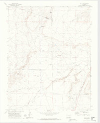 1970 Delhi1974 Print · USGSSoutheast Colorado ranching country is captured here just as the modern era reached these high plains. Genealogists and historians can trace family-named sites like Hall Windmills and Barbee Windmill along the path of the Santa Fe Trail.2 unique versions available
 - 1982 Map of Walsenburg
 1982 Walsenburg1982 Print · USGSThe Huerfano valley in the early eighties shows a landscape of mining camps and cattle country. Genealogists can trace family names at Masonic Cem or locate old industrial sites like the Pacific Mine and the rail junction at Walsenburg.
 - 1988 Map of Trinidad
 1988 Trinidad1988 Print · USGSSouthern Colorado in the late eighties reveals a landscape of high-altitude farming and mountain rail corridors. Genealogists and historians can trace the foundations of San Luis and Fort Garland or find old stops on the D & R G W RR and A T & S F Ry.
 - 1993 Map of Delhi
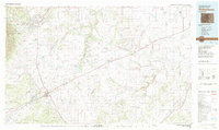
 1993 Delhi1993 Print · USGSThe high plains of the Colorado borderlands are captured here in the early 1990s, where the Santa Fe railroad meets the Comanche National Grassland. Researchers can trace old ranching infrastructure through local landmarks like Barbee Windmill, Hixon Spring, and the small settlement of Delhi.
 - 1996 Map of Delhi, 2000 Print
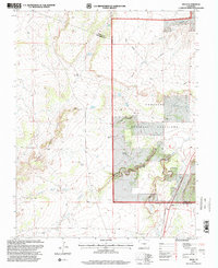 1996 Delhi2000 Print · USGSThe high plains of Las Animas County come into focus during the mid-nineties, showing the intersection of ranching infrastructure and historic western routes. Trace the path of the Santa Fe Historic Trail near Delhi and locate family-named landmarks like the Barbee Windmill and Deal Windmill.
End of results
Showing maps 1-9 of 9
Frequently asked questions
- What are the different types of historical maps available for Delhi?
- What is the oldest map of Delhi?
- Where can I purchase historical maps of Delhi for my home or office?
- Where can I download high-res historical maps of Delhi?
- Are there historical topographic maps available for Delhi?
- Is there historical aerial imagery available for Delhi?
- Where are historical maps of Delhi sourced from?