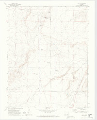
1970 Map of Delhi
USGS Topo · Published 1974About this map
The settlement of Delhi sits at the intersection of long-distance transport and desert water sources, positioned where the Atchison Topeka and Santa Fe railroad corridor meets the historic Santa Fe Trail. This landscape is defined by its drainage systems, including the deeply carved Poitrey Canyon and Timpas Creek, which flow through a region of scrub and bluffs.
Find a feature on this map
24 named features on this map. Tap any name to fly to it.
Don’t see what you’re looking for? This feature index may not catch every label — zoom into the map to look around manually.
Map Details
Editions of this 1970 Delhi Map
2 editions found
Other maps of this area

1891 · Timpas
USGS Topo · 1:125,000

1891 · Apishapa
USGS Topo · 1:125,000

1893 · Apishapa
USGS Topo · 1:125,000

1894 · Timpas
USGS Topo · 1:125,000

1897 · Apishapa
USGS Topo · 1:125,000

1954 · Trinidad
USGS Topo · 1:250,000

1955 · La Junta
USGS Topo · 1:250,000

1955 · Trinidad
USGS Topo · 1:250,000

1958 · La Junta
USGS Topo · 1:250,000

1958 · Trinidad
USGS Topo · 1:250,000