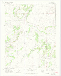
1970 Map of Delhi
USGS Topo · Published 1974About this map
Delhi and its surroundings in southeastern Colorado appear as a landscape defined by the intersection of early transport history and cattle-country water infrastructure. The historic Santa Fe Trail and the Atchison Topeka and Santa Fe railroad run parallel through the eastern portion of the quadrangle, following the course of Timpas Creek. The interior terrain is marked by essential watering points for ranchers, including Hizon Spring, Christian Spring, and several family-named wells such as the Barbee Windmill, Deal Windmill, and Wenzel Windmill. The map reveals the intricate network of drainage systems like Poitrey Arroyo and Wild Horse Arroyo that carve through the high plains. The convergence of multiple county lines, including Pueblo, Otero, and Las Animas, highlights the location's significance as a borderlands region where geography and political boundaries meet.
Find a feature on this map
26 named features on this map. Tap any name to fly to it.
Don’t see what you’re looking for? This feature index may not catch every label — zoom into the map to look around manually.
Map Details
Editions of this 1970 Delhi Map
2 editions found
Other maps of this area

1891 · Timpas
USGS Topo · 1:125,000

1891 · Apishapa
USGS Topo · 1:125,000

1893 · Apishapa
USGS Topo · 1:125,000

1894 · Timpas
USGS Topo · 1:125,000

1897 · Apishapa
USGS Topo · 1:125,000

1954 · Trinidad
USGS Topo · 1:250,000

1955 · La Junta
USGS Topo · 1:250,000

1955 · Trinidad
USGS Topo · 1:250,000

1958 · La Junta
USGS Topo · 1:250,000

1958 · Trinidad
USGS Topo · 1:250,000