1940s Maps of Uravan, Colorado
Explore 2 historic maps of Uravan from the 1940s. These maps offer a rare glimpse into what life looked like during the 1940s — showing old roads, neighborhoods, homes, and landmarks that have changed or disappeared over time.
Whether you're researching your family's past, planning a metal detecting trip, or studying how Uravan's landscape evolved across the 1940s, these high-resolution maps are a powerful tool for exploring the history of this region.
- Focus on a specific era: All maps on this page are from the 1940s, giving you a focused view of this time period.
- See what’s changed: Compare century-old streets, trails, and buildings to today's modern landscape using overlays and satellite layers.
- Research with precision: Use these maps for genealogy, historical research, land use analysis, or educational projects.
- View, download, or print: Maps are fully viewable online in high resolution, and can be downloaded or printed for your own records.
Start exploring Uravan's history through authentic maps from the 1940s. This is your window into the past.
Uravan, CO maps
(2)- 1948 Map of Uravan, 1955 Print
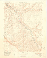
 1948 Uravan1955 Print · USGSMining operations along the San Miguel River are at their peak in the late 1940s as the atomic era begins. Researchers can trace the industrial footprint of uranium production through local landmarks like the Club Mines, Uravan, and the Bitter Creek Mines.2 unique versions available
 - 1949 Map of Uravan
 1949 Uravan1949 Print · USGSThe mining community of Uravan sits at a crossroads of Cold War industry and high-desert geography in the late 1940s. Genealogists and historians can trace numerous specific extraction sites like the Media Mine, Fortyfive-Ninety Mine, and the Bitter Creek Mines.2 unique versions available
End of results
Showing maps 1-2 of 2
Top cities near Uravan
Frequently asked questions
- What are the different types of historical maps available for Uravan?
- What is the oldest map of Uravan?
- Where can I purchase historical maps of Uravan for my home or office?
- Where can I download high-res historical maps of Uravan?
- Are there historical topographic maps available for Uravan?
- Is there historical aerial imagery available for Uravan?
- Where are historical maps of Uravan sourced from?