1990s Maps of Bloom, Colorado
Explore 2 historic maps of Bloom from the 1990s. These maps offer a rare glimpse into what life looked like during the 1990s — showing old roads, neighborhoods, homes, and landmarks that have changed or disappeared over time.
Whether you're researching your family's past, planning a metal detecting trip, or studying how Bloom's landscape evolved across the 1990s, these high-resolution maps are a powerful tool for exploring the history of this region.
- Focus on a specific era: All maps on this page are from the 1990s, giving you a focused view of this time period.
- See what’s changed: Compare century-old streets, trails, and buildings to today's modern landscape using overlays and satellite layers.
- Research with precision: Use these maps for genealogy, historical research, land use analysis, or educational projects.
- View, download, or print: Maps are fully viewable online in high resolution, and can be downloaded or printed for your own records.
Start exploring Bloom's history through authentic maps from the 1990s. This is your window into the past.
Bloom, CO maps
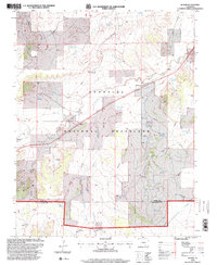
(2)- 1993 Map of Bloom
 1993 Bloom1993 Print · USGSSoutheast Colorado's high plains reveal a landscape of transit and ranching in the early nineties, where the Historic Santa Fe Trail follows the same path as the railroad. Researchers can trace the small settlement at Bloom or locate family-named landmarks like Cochran Reservoir and Fultz Reservoir.
 - 1996 Map of Bloom, 2000 Print
 1996 Bloom2000 Print · USGSThe Colorado high plains near the Otero and Las Animas county line appear here in the mid-1990s, dominated by the wide reaches of the Comanche National Grassland. Genealogists and historians can trace the Santa Fe National Historic Trail past Bloom and locate isolated Graves and ranch landmarks like Corral Well.
End of results
Showing maps 1-2 of 2
Frequently asked questions
- What are the different types of historical maps available for Bloom?
- What is the oldest map of Bloom?
- Where can I purchase historical maps of Bloom for my home or office?
- Where can I download high-res historical maps of Bloom?
- Are there historical topographic maps available for Bloom?
- Is there historical aerial imagery available for Bloom?
- Where are historical maps of Bloom sourced from?