1960s Maps of La Junta Gardens, Colorado
Explore 2 historic maps of La Junta Gardens from the 1960s. These maps offer a rare glimpse into what life looked like during the 1960s — showing old roads, neighborhoods, homes, and landmarks that have changed or disappeared over time.
Whether you're researching your family's past, planning a metal detecting trip, or studying how La Junta Gardens's landscape evolved across the 1960s, these high-resolution maps are a powerful tool for exploring the history of this region.
- Focus on a specific era: All maps on this page are from the 1960s, giving you a focused view of this time period.
- See what’s changed: Compare century-old streets, trails, and buildings to today's modern landscape using overlays and satellite layers.
- Research with precision: Use these maps for genealogy, historical research, land use analysis, or educational projects.
- View, download, or print: Maps are fully viewable online in high resolution, and can be downloaded or printed for your own records.
Start exploring La Junta Gardens's history through authentic maps from the 1960s. This is your window into the past.
La Junta Gardens, CO maps
(2)- 1966 Map of La Junta, 1970 Print
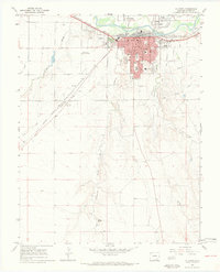 1966 La Junta1970 Print · USGSLa Junta during the mid-1960s was a bustling railroad and education hub on the Arkansas River. Historians can trace the development of neighborhood schools like Columbian Sch and Jr High Sch, or locate family sites near Fairview Cem and the Otero Jr College campus.4 unique versions available
 - 1968 Map of La Junta
 1968 La Junta1968 Print · USGSSoutheastern Colorado and the high plains appear in remarkable detail during the late 1960s, showing the intersection of irrigation, ranching, and rail. Genealogists can trace family footprints at the Lycan Post Office, Konantz Cem, and across numerous named cattle ranches.
End of results
Showing maps 1-2 of 2
Top cities near La Junta Gardens
- La Junta historical maps
- Rocky Ford historical maps
- Ordway historical maps
- Swink historical maps
- Cheraw historical maps
Frequently asked questions
- What are the different types of historical maps available for La Junta Gardens?
- What is the oldest map of La Junta Gardens?
- Where can I purchase historical maps of La Junta Gardens for my home or office?
- Where can I download high-res historical maps of La Junta Gardens?
- Are there historical topographic maps available for La Junta Gardens?
- Is there historical aerial imagery available for La Junta Gardens?
- Where are historical maps of La Junta Gardens sourced from?