1990s Maps of Ouray County, Colorado
Explore 2 historic maps of Ouray County from the 1990s. These maps offer a rare glimpse into what life looked like during the 1990s — showing old roads, neighborhoods, homes, and landmarks that have changed or disappeared over time.
Whether you're researching your family's past, planning a metal detecting trip, or studying how Ouray County's landscape evolved across the 1990s, these high-resolution maps are a powerful tool for exploring the history of this region.
- Focus on a specific era: All maps on this page are from the 1990s, giving you a focused view of this time period.
- See what’s changed: Compare century-old streets, trails, and buildings to today's modern landscape using overlays and satellite layers.
- Research with precision: Use these maps for genealogy, historical research, land use analysis, or educational projects.
- View, download, or print: Maps are fully viewable online in high resolution, and can be downloaded or printed for your own records.
Start exploring Ouray County's history through authentic maps from the 1990s. This is your window into the past.
Ouray County, CO maps
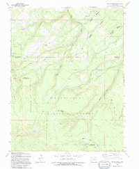
(2)- 1994 Map of Antone Spring
 1994 Antone Spring1994 Print · USGSHigh-altitude grazing lands and forest service routes define this Montrose County landscape in the early nineties. Researchers can trace historic seasonal outposts like Gray Cow Camp and Lary Y Cow Camp or explore remote paths such as the Roubideau Trail.
 - 1994 Map of Pryor Creek
 1994 Pryor Creek1994 Print · USGSThe high country of the Uncompahgre Plateau is captured in the 1990s as it straddles the Montrose and Ouray county lines. Trace historic travel routes like the Old Paradox Road and locate remote outposts such as Silesca Guard Sta and Donley Camp.
End of results
Showing maps 1-2 of 2
Top cities of Ouray County
Frequently asked questions
- What are the different types of historical maps available for Ouray County?
- What is the oldest map of Ouray County?
- Where can I purchase historical maps of Ouray County for my home or office?
- Where can I download high-res historical maps of Ouray County?
- Are there historical topographic maps available for Ouray County?
- Is there historical aerial imagery available for Ouray County?
- Where are historical maps of Ouray County sourced from?