1900s (20th Century) Maps of Lamar, Colorado
Explore 6 historic maps of Lamar from the 1900s (20th Century). These maps offer a rare glimpse into what life looked like during the 1900s — showing old roads, neighborhoods, homes, and landmarks that have changed or disappeared over time.
Whether you're researching your family's past, planning a metal detecting trip, or studying how Lamar's landscape evolved across the 1900s, these high-resolution maps are a powerful tool for exploring the history of this region.
- Focus on a specific era: All maps on this page are from the 1900s, giving you a focused view of this time period.
- See what’s changed: Compare century-old streets, trails, and buildings to today's modern landscape using overlays and satellite layers.
- Research with precision: Use these maps for genealogy, historical research, land use analysis, or educational projects.
- View, download, or print: Maps are fully viewable online in high resolution, and can be downloaded or printed for your own records.
Start exploring Lamar's history through authentic maps from the 1900s. This is your window into the past.
Lamar, CO maps
(6)- 1952 Map of Lamar West, 1954 Print
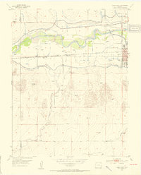 1952 Lamar West1954 Print · USGSThe river valley west of Lamar was a vital corridor for both historic wagon routes and modern irrigation during the early fifties. Genealogists and historians can trace the Old Santa Fe Trail alongside local landmarks like Dry Creek School and Crawford Cem.4 unique versions available
 - 1953 Map of Lamar East, 1954 Print
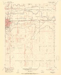 1953 Lamar East1954 Print · USGSThe Arkansas River valley in the early fifties shows a landscape of vital irrigation and railroad history. Trace the route of the Santa Fe Trail and find local landmarks like Riverside Cemetery, Clay Creek School, and the Lamar city limits.5 unique versions available
 - 1954 Map of Lamar, 1964 Print
 1954 Lamar1964 Print · USGSSoutheastern Colorado and the Kansas borderlands appear here in the mid-fifties, dominated by the vital Arkansas River irrigation network. Researchers can trace the development of river towns like Lamar and La Junta alongside the Amity Cemetery and several major reservoirs.3 unique versions available
 - 1958 Map of Lamar
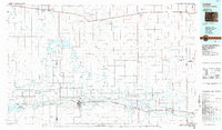
 1958 Lamar1958 Print · USGSThe High Plains of Eastern Colorado and Western Kansas in the late fifties reveal a landscape tied to the Arkansas River and the rails. Trace the heritage of the river valley through Fort Lyon, the Atchison Topeka and Santa Fe RR, and rural landmarks like Kendrick Church.2 unique versions available
 - 1984 Map of Lamar, 1985 Print
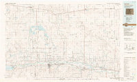
 1984 Lamar1985 Print · USGSSoutheastern Colorado and the Kansas borderlands appear here in the mid-1980s as a landscape shaped by irrigation and dual railroad lines. Researchers can trace the river-valley towns of Lamar and Granada or locate prairie outposts like Towner and Brandon.
 - 1988 Map of Lamar
 1988 Lamar1988 Print · USGSSoutheastern Colorado and western Kansas reveal a landscape of deep history and complex irrigation in the late eighties. Researchers can trace the storied Santa Fe Trail and explore sites like Camp Amache and the Brandon Oil Field.
End of results
Showing maps 1-6 of 6
Top cities near Lamar
Frequently asked questions
- What are the different types of historical maps available for Lamar?
- What is the oldest map of Lamar?
- Where can I purchase historical maps of Lamar for my home or office?
- Where can I download high-res historical maps of Lamar?
- Are there historical topographic maps available for Lamar?
- Is there historical aerial imagery available for Lamar?
- Where are historical maps of Lamar sourced from?