1910s Maps of Rio Grande County, Colorado
Explore 6 historic maps of Rio Grande County from the 1910s. These maps offer a rare glimpse into what life looked like during the 1910s — showing old roads, neighborhoods, homes, and landmarks that have changed or disappeared over time.
Whether you're researching your family's past, planning a metal detecting trip, or studying how Rio Grande County's landscape evolved across the 1910s, these high-resolution maps are a powerful tool for exploring the history of this region.
- Focus on a specific era: All maps on this page are from the 1910s, giving you a focused view of this time period.
- See what’s changed: Compare century-old streets, trails, and buildings to today's modern landscape using overlays and satellite layers.
- Research with precision: Use these maps for genealogy, historical research, land use analysis, or educational projects.
- View, download, or print: Maps are fully viewable online in high resolution, and can be downloaded or printed for your own records.
Start exploring Rio Grande County's history through authentic maps from the 1910s. This is your window into the past.
Rio Grande County, CO maps
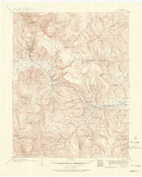
(6)- 1913 Map of Summitville, 1962 Print
 1913 Summitville1962 Print · USGSThe high San Juan Mountains at the turn of the century are captured here, from the gold-mining district at Summitville to the ranchlands of the Navajo River valley. Genealogists and historians can trace early school sites like Blanco School and working mines including the Asiatic Mine and Forest King Mine.
 - 1914 Map of Creede
 1914 Creede1914 Print · USGSMineral County mining camps and silver-era infrastructure are preserved in this pre-war survey. Genealogists and historians can trace industrial landmarks like the Nelson Tunnel alongside early settlements including Bachelor, Sunnyside, and Spar City.3 unique versions available
 - 1915 Map of Summitville
 1915 Summitville1915 Print · USGSSouthern Colorado mining and timber operations are captured here during the early twentieth century. Researchers can trace remote mining claims like the Asiatic Mine, mountain schools such as Blanco School, and the path of the Logging RR.4 unique versions available
 - 1915 Map of Del Norte, 1957 Print
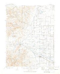 1915 Del Norte1957 Print · USGSThe San Luis Valley was a thriving agricultural and rail hub during the early twentieth century. Researchers can trace the legacy of early settlements and rural schoolhouses like La Garita School, Swede Lane School, and the Denver and Rio Grande rail line.
 - 1916 Map of Creede
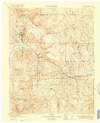 1916 Creede1916 Print · USGSThe silver boom of the San Juan Mountains is in full swing on this 1910s survey of the upper Rio Grande. Researchers can trace mining claims and tunnels at Bachelor, locate the Emma Mine, or find the old Pfeiffer School near Granger.3 unique versions available
 - 1917 Map of Del Norte
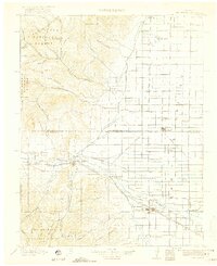 1917 Del Norte1917 Print · USGSThe San Luis Valley thrives in the mid-1910s as irrigation transforms the high desert into a productive agricultural hub. Researchers can locate dozens of country schools like Eureka School and trace the Denver and Rio Grande rail corridor through Monte Vista.3 unique versions available
End of results
Showing maps 1-6 of 6
Top cities of Rio Grande County
Frequently asked questions
- What are the different types of historical maps available for Rio Grande County?
- What is the oldest map of Rio Grande County?
- Where can I purchase historical maps of Rio Grande County for my home or office?
- Where can I download high-res historical maps of Rio Grande County?
- Are there historical topographic maps available for Rio Grande County?
- Is there historical aerial imagery available for Rio Grande County?
- Where are historical maps of Rio Grande County sourced from?