1970s Maps of Milner, Colorado
Explore 2 historic maps of Milner from the 1970s. These maps offer a rare glimpse into what life looked like during the 1970s — showing old roads, neighborhoods, homes, and landmarks that have changed or disappeared over time.
Whether you're researching your family's past, planning a metal detecting trip, or studying how Milner's landscape evolved across the 1970s, these high-resolution maps are a powerful tool for exploring the history of this region.
- Focus on a specific era: All maps on this page are from the 1970s, giving you a focused view of this time period.
- See what’s changed: Compare century-old streets, trails, and buildings to today's modern landscape using overlays and satellite layers.
- Research with precision: Use these maps for genealogy, historical research, land use analysis, or educational projects.
- View, download, or print: Maps are fully viewable online in high resolution, and can be downloaded or printed for your own records.
Start exploring Milner's history through authentic maps from the 1970s. This is your window into the past.
Milner, CO maps
(2)- 1971 Map of Milner, 1974 Print
 1971 Milner1974 Print · USGSRoutt County mining and rail operations are in full swing in the early 1970s along the Yampa River. Researchers can trace the industrial footprint of the Tow Creek Oil Field and locate vanished landmarks like Coal View (Site) and Mc Gregor.3 unique versions available
 - 1979 Map of Meeker
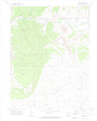
 1979 Meeker1979 Print · USGSNorthwestern Colorado in the late seventies reveals a landscape of high-country wilderness and expanding energy production. Researchers can trace the Denver and Rio Grande Western RR as it serves the Energy Mine and Coal View Mine, or locate the Thornburgh Historical Site and Meeker Cemetery.
End of results
Showing maps 1-2 of 2
Top cities near Milner
Frequently asked questions
- What are the different types of historical maps available for Milner?
- What is the oldest map of Milner?
- Where can I purchase historical maps of Milner for my home or office?
- Where can I download high-res historical maps of Milner?
- Are there historical topographic maps available for Milner?
- Is there historical aerial imagery available for Milner?
- Where are historical maps of Milner sourced from?