1970s Maps of Breckenridge, Colorado
Explore 2 historic maps of Breckenridge from the 1970s. These maps offer a rare glimpse into what life looked like during the 1970s — showing old roads, neighborhoods, homes, and landmarks that have changed or disappeared over time.
Whether you're researching your family's past, planning a metal detecting trip, or studying how Breckenridge's landscape evolved across the 1970s, these high-resolution maps are a powerful tool for exploring the history of this region.
- Focus on a specific era: All maps on this page are from the 1970s, giving you a focused view of this time period.
- See what’s changed: Compare century-old streets, trails, and buildings to today's modern landscape using overlays and satellite layers.
- Research with precision: Use these maps for genealogy, historical research, land use analysis, or educational projects.
- View, download, or print: Maps are fully viewable online in high resolution, and can be downloaded or printed for your own records.
Start exploring Breckenridge's history through authentic maps from the 1970s. This is your window into the past.
Breckenridge, CO maps
(2)- 1970 Map of Frisco, 1973 Print
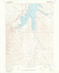 1970 Frisco1973 Print · USGSFrisco and the Blue River valley appear in the early 1970s as the landscape shifts toward recreation and water storage. Researchers can locate the Masontown site, the Dillon Cem, and mining relics like the dredge near Delaware Flats.4 unique versions available
 - 1970 Map of Breckenridge, 1973 Print
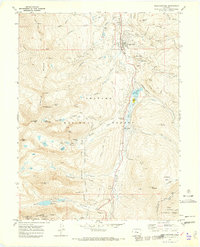 1970 Breckenridge1973 Print · USGSThe high-altitude mining and ski country of the Tenmile Range is captured here in the early 1970s. Researchers can trace the legacy of the gold era at the Wellington Mine and dredge tailings alongside the emerging Sawmill Ski Area ski lifts.3 unique versions available
End of results
Showing maps 1-2 of 2
Top cities near Breckenridge
- Silverthorne historical maps
- Frisco historical maps
- Dillon historical maps
- Blue River historical maps
- Alma historical maps
- Montezuma historical maps
See more
Frequently asked questions
- What are the different types of historical maps available for Breckenridge?
- What is the oldest map of Breckenridge?
- Where can I purchase historical maps of Breckenridge for my home or office?
- Where can I download high-res historical maps of Breckenridge?
- Are there historical topographic maps available for Breckenridge?
- Is there historical aerial imagery available for Breckenridge?
- Where are historical maps of Breckenridge sourced from?