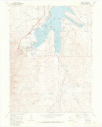
1970 Map of Frisco
USGS Topo · Published 1973About this map
Dillon Reservoir dominates this high-altitude landscape, its waters having altered the local geography as a primary feature of the Denver water system. The map captures the town of Frisco during a period of transition, showing the infrastructure of the newly established Swan Mountain Recreation Area and the U S Air Force Recreation Area alongside older mining-era remnants. To the south, the site of Masontown and the presence of a dredge on the Blue River near Braddock Flats point to the area's rich mineral history and the industrial-scale gold extraction that once reshaped the river valley.
Find a feature on this map
75 named features on this map. Tap any name to fly to it.
Don’t see what you’re looking for? This feature index may not catch every label — zoom into the map to look around manually.
Map Details
Editions of this 1970 Frisco Map
4 editions found
Other maps of this area

1889 · Leadville
USGS Topo · 1:125,000

1891 · Leadville
USGS Topo · 1:125,000

1924 · Montezuma
USGS Topo · 1:62,500

1926 · Montezuma
USGS Topo · 1:62,500

1929 · Dillon
USGS Topo · 1:62,500

1933 · Montezuma
USGS Topo · 1:62,500

1934 · Climax
USGS Topo · 1:48,000

1934 · Dillon
USGS Topo · 1:62,500

1937 · Como
USGS Topo · 1:62,500

1938 · Mt. Lincoln
USGS Topo · 1:48,000