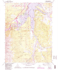
1970 Map of Frisco
USGS Topo · Published 1988About this map
Dillon Reservoir and the Blue River valley dominate this survey of Summit County during a period of significant recreational expansion. The map details the complex shoreline of the reservoir, including the Peninsula Recreation Area, Sentinel Island, and the massive Glory Hole spillway near the Dillon Overlook. West of the water, the town of Frisco is shown alongside legacy sites like the Masontown (Site) and Bills Ranch. The landscape transitions from the developed valley floor to the high peaks of the Tenmile Range, featuring Tenmile Peak and the numbered summits from Peak 1 to Peak 5. Evidence of the region's mining history remains visible through numerous Mines and the extensive Dredge Tailings along the Swan River, while the southern portion of the sheet notes the Breckenridge Airport and Braddock Flats.
Find a feature on this map
73 named features on this map. Tap any name to fly to it.
Don’t see what you’re looking for? This feature index may not catch every label — zoom into the map to look around manually.
Map Details
Editions of this 1970 Frisco Map
4 editions found
Other maps of this area

1889 · Leadville
USGS Topo · 1:125,000

1891 · Leadville
USGS Topo · 1:125,000

1924 · Montezuma
USGS Topo · 1:62,500

1926 · Montezuma
USGS Topo · 1:62,500

1929 · Dillon
USGS Topo · 1:62,500

1933 · Montezuma
USGS Topo · 1:62,500

1934 · Climax
USGS Topo · 1:48,000

1934 · Dillon
USGS Topo · 1:62,500

1937 · Como
USGS Topo · 1:62,500

1938 · Mt. Lincoln
USGS Topo · 1:48,000