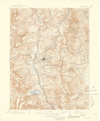
1889 Map of Leadville
USGS Topo · Published 1955About this map
Leadville serves as the industrial and social heart of this high-altitude survey, surrounded by a complex network of mining camps and alpine infrastructure during the height of the silver boom. The landscape is defined by its verticality, from the peaks of Holy Cross and M' Massive to the deep basins of Twin Lakes. Early mountain transit is captured through the Denver and Rio Grande Railroad and the Colorado Midland Railway, which navigate treacherous passes like Tennessee Pass and the engineering feat of the Hagerman Tunnel.
Find a feature on this map
166 named features on this map. Tap any name to fly to it.
Don’t see what you’re looking for? This feature index may not catch every label — zoom into the map to look around manually.
Map Details
Editions of this 1889 Leadville Map
This is the sole edition of this map. No revisions or reprints were ever made.
Historical Maps of Breckenridge Through Time
9 maps found