1940s Maps of Westminster, Colorado
Explore 9 historic maps of Westminster from the 1940s. These maps offer a rare glimpse into what life looked like during the 1940s — showing old roads, neighborhoods, homes, and landmarks that have changed or disappeared over time.
Whether you're researching your family's past, planning a metal detecting trip, or studying how Westminster's landscape evolved across the 1940s, these high-resolution maps are a powerful tool for exploring the history of this region.
- Focus on a specific era: All maps on this page are from the 1940s, giving you a focused view of this time period.
- See what’s changed: Compare century-old streets, trails, and buildings to today's modern landscape using overlays and satellite layers.
- Research with precision: Use these maps for genealogy, historical research, land use analysis, or educational projects.
- View, download, or print: Maps are fully viewable online in high resolution, and can be downloaded or printed for your own records.
Start exploring Westminster's history through authentic maps from the 1940s. This is your window into the past.
Westminster, CO maps
(9)- 1940 Map of Eastlake
 1940 Eastlake1940 Print · USGSAdams County at the end of the 1930s shows a landscape of rail-side settlements and intensive irrigation. Genealogists can locate family landmarks like Wesley Chapel, rural school sites such as Moreland Sch, and the water networks of the Brantner Ditch.
 - 1940 Map of Lafayette
 1940 Lafayette1940 Print · USGSLafayette and the northern Colorado coalfields are captured in the late 1930s as mining and rail transport shaped the local economy. Genealogists can trace family roots through named landmarks like Mandalay Sch, Lakeview Cem, and the Centennial Mine.
 - 1941 Map of Arvada
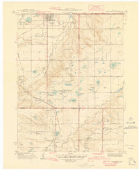
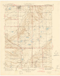
 1941 Arvada1941 Print · USGSThe Arvada and Westminster areas of the Colorado Front Range appear here in the early 1940s, showing a landscape defined by irrigation and rail. Researchers can trace historic institutions like Bellevue College, early settlements at Utah Junction, and the Leyden Narrow Gage railroad.
 - 1942 Map of Golden
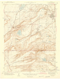
 1942 Golden1942 Print · USGSJefferson County before the post-war suburban boom reveals a landscape of industrial transit and coordinated irrigation. Researchers can trace the path of the Denver and Intermountain (Electric) line or locate rural community hubs like Ralston Ch and Fairmount Sch.
 - 1942 Map of Louisville
 1942 Louisville1942 Print · USGSLouisville and the high plains of Boulder County are captured here just before the mid-century expansion. Genealogists and historians can trace the early footprints of Superior, Marshall, and Louisville, or locate rural landmarks like the Sacred Heart Ch and Shamrock Sch.3 unique versions available
 - 1944 Map of Arvada
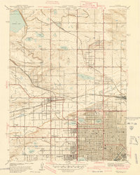
 1944 Arvada1944 Print · USGSThe northwest Denver suburbs appear as a series of distinct rail-connected towns in the 1940s. Genealogists can locate family landmarks like Arvada Cem, Semper Sch, and the grounds of Regis College.
 - 1944 Map of Lafayette
 1944 Lafayette1944 Print · USGSThe northern Front Range in the years following the Great Depression was a landscape of coal mines and intricate irrigation reservoirs. You can trace the early footprints of Lafayette and Broomfield while locating industrial landmarks like the Centennial Mine and Burn Lee Sch.
 - 1944 Map of Eastlake
 1944 Eastlake1944 Print · USGSThe South Platte River valley and the agricultural plains of Adams County appear here in the years before the Denver suburbs arrived. Genealogists and historians can trace rural family life through locations like Wesley Chapel, the local Cemetery, and early school sites like Brantner Sch.
 - 1944 Map of Golden
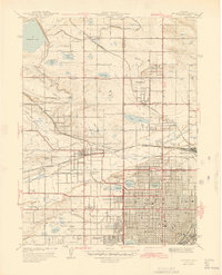
 1944 Golden1944 Print · USGSGolden and the surrounding Jefferson County plains are shown during the early war years, framed by the iconic Table Mountains. Researchers can locate vanished landmarks like the Camp George West and local schools including Fremont Sch and Ralston Sch.
End of results
Showing maps 1-9 of 9
Top cities near Westminster
- Denver historical maps
- Aurora historical maps
- Lakewood historical maps
- Thornton historical maps
- Arvada historical maps
- Boulder historical maps
See more
Top neighborhoods of Westminster
- Wallace Village historical maps
- Northridge Manor historical maps
- Bradburn historical maps
- Cedar Bridge historical maps
- Hillcrest historical maps
- The Meadows at Timber Lake historical maps
See more
Frequently asked questions
- What are the different types of historical maps available for Westminster?
- What is the oldest map of Westminster?
- Where can I purchase historical maps of Westminster for my home or office?
- Where can I download high-res historical maps of Westminster?
- Are there historical topographic maps available for Westminster?
- Is there historical aerial imagery available for Westminster?
- Where are historical maps of Westminster sourced from?