1940s Maps of Willington, Connecticut
Explore 6 historic maps of Willington from the 1940s. These maps offer a rare glimpse into what life looked like during the 1940s — showing old roads, neighborhoods, homes, and landmarks that have changed or disappeared over time.
Whether you're researching your family's past, planning a metal detecting trip, or studying how Willington's landscape evolved across the 1940s, these high-resolution maps are a powerful tool for exploring the history of this region.
- Focus on a specific era: All maps on this page are from the 1940s, giving you a focused view of this time period.
- See what’s changed: Compare century-old streets, trails, and buildings to today's modern landscape using overlays and satellite layers.
- Research with precision: Use these maps for genealogy, historical research, land use analysis, or educational projects.
- View, download, or print: Maps are fully viewable online in high resolution, and can be downloaded or printed for your own records.
Start exploring Willington's history through authentic maps from the 1940s. This is your window into the past.
Willington, CT maps
(6)- 1944 Map of South Coventry
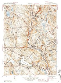 1944 South Coventry1944 Print · USGSTolland County at the close of the Second World War shows a landscape defined by the Willimantic River valley and the growing University of Connecticut. Genealogists and historians can trace the Central Vermont rail line through Mansfield Depot or locate family roots near the Nathan Hale Birthplace and Eagleville.3 unique versions available
 - 1945 Map of Spring Hill
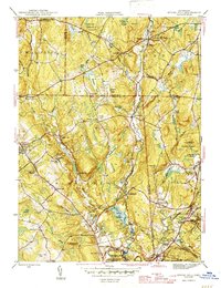 1945 Spring Hill1945 Print · USGSTolland and Windham Counties are documented here in the mid-1940s, highlighting the rural character of Mansfield and Chaplin. Researchers can find numerous family-named landmarks and old burial sites, including Wormwood Hill Cem, Bedlam Corner, and the early University of Connecticut campus.2 unique versions available
 - 1945 Map of Westford
 1945 Westford1945 Print · USGSThe borderlands of Windham and Tolland Counties are shown here during the mid-forties, a landscape of quiet hill towns and state forests. Genealogists and historians can trace local roots at the Swamp Burying Ground, Westford Hill Ch, and the old Red Sch.2 unique versions available
 - 1946 Map of Stafford Springs
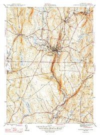 1946 Stafford Springs1946 Print · USGSTolland County at the end of the Second World War centers on the busy mill towns and rail lines of the upper Willimantic valley. You can trace the Central Vermont railroad through Stafford Springs and locate local family history at Old Stafford Street Cemetery or Hydeville.2 unique versions available
 - 1947 Map of Hartford, 1955 Print
 1947 Hartford1955 Print · USGSSouthern New England and the Hudson Valley are shown in detail during the post-war expansion era. Genealogists and researchers can trace local landmarks from the State Capitol and Yale University to the Stratford Lighthouse and Woodlawn Cem.2 unique versions available
 - 1948 Map of Hartford
 1948 Hartford1948 Print · USGSSouthern New England is captured here in the late 1940s, showcasing a landscape of thriving industrial cities and developing parkways. Genealogists and historians can trace the rail networks of the New York New Haven and Hartford RR or locate coastal defense sites like Fort Terry and Camp Shanks.2 unique versions available
End of results
Showing maps 1-6 of 6
Top cities near Willington
- Springfield historical maps
- Manchester historical maps
- Glastonbury historical maps
- Vernon historical maps
- Mansfield historical maps
- Windham historical maps
See more
Top neighborhoods of Willington
- South Willington historical maps
- Willington Hill historical maps
- West Willington historical maps
- East Willington historical maps
Frequently asked questions
- What are the different types of historical maps available for Willington?
- What is the oldest map of Willington?
- Where can I purchase historical maps of Willington for my home or office?
- Where can I download high-res historical maps of Willington?
- Are there historical topographic maps available for Willington?
- Is there historical aerial imagery available for Willington?
- Where are historical maps of Willington sourced from?