1920s Maps of Windsor, Connecticut
Explore 4 historic maps of Windsor from the 1920s. These maps offer a rare glimpse into what life looked like during the 1920s — showing old roads, neighborhoods, homes, and landmarks that have changed or disappeared over time.
Whether you're researching your family's past, planning a metal detecting trip, or studying how Windsor's landscape evolved across the 1920s, these high-resolution maps are a powerful tool for exploring the history of this region.
- Focus on a specific era: All maps on this page are from the 1920s, giving you a focused view of this time period.
- See what’s changed: Compare century-old streets, trails, and buildings to today's modern landscape using overlays and satellite layers.
- Research with precision: Use these maps for genealogy, historical research, land use analysis, or educational projects.
- View, download, or print: Maps are fully viewable online in high resolution, and can be downloaded or printed for your own records.
Start exploring Windsor's history through authentic maps from the 1920s. This is your window into the past.
Windsor, CT maps
(4)- 1928 Map of Windsor Locks
 1928 Windsor Locks1928 Print · USGSThe northern Connecticut River Valley is captured here in the late 1920s during a period of industrial and agricultural prosperity. Researchers can trace the path of the New York New Haven and Hartford railroad through Windsor Locks and Poquonock.
 - 1928 Map of Windsor
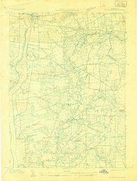
 1928 Windsor1928 Print · USGSGreater Hartford was entering a period of suburban growth in the late 1920s, bridging the gap between the city and the riverside towns of the Connecticut Valley. You can trace early street grids and rail lines serving Windsor, Cottage Grove, and East Hartford.
 - 1928 Map of Broad Brook
 1928 Broad Brook1928 Print · USGSNorthern Connecticut’s river valley and fertile uplands are preserved here as they appeared in the late twenties. Genealogists and local historians can trace family-named hubs like Sadd's Mills and Osborne or locate old crossings at Warehouse Point.
 - 1928 Map of Manchester
 1928 Manchester1928 Print · USGSHartford County's industrial and rural landscape is captured here in the late twenties, during a period of significant regional growth. Researchers can trace the path of the New York New Haven and Hartford railroad through local hubs like Buckland and Manchester Green.
End of results
Showing maps 1-4 of 4
Top cities near Windsor
- Springfield historical maps
- Hartford historical maps
- New Britain historical maps
- West Hartford historical maps
- Bristol historical maps
- Manchester historical maps
See more
Top neighborhoods of Windsor
- Birchwood historical maps
- Hayden historical maps
- Wilson historical maps
- Breakneck historical maps
- Rainbow historical maps
- Poquonock historical maps
See more
Frequently asked questions
- What are the different types of historical maps available for Windsor?
- What is the oldest map of Windsor?
- Where can I purchase historical maps of Windsor for my home or office?
- Where can I download high-res historical maps of Windsor?
- Are there historical topographic maps available for Windsor?
- Is there historical aerial imagery available for Windsor?
- Where are historical maps of Windsor sourced from?