1950s Maps of Windsor, Connecticut
Explore 4 historic maps of Windsor from the 1950s. These maps offer a rare glimpse into what life looked like during the 1950s — showing old roads, neighborhoods, homes, and landmarks that have changed or disappeared over time.
Whether you're researching your family's past, planning a metal detecting trip, or studying how Windsor's landscape evolved across the 1950s, these high-resolution maps are a powerful tool for exploring the history of this region.
- Focus on a specific era: All maps on this page are from the 1950s, giving you a focused view of this time period.
- See what’s changed: Compare century-old streets, trails, and buildings to today's modern landscape using overlays and satellite layers.
- Research with precision: Use these maps for genealogy, historical research, land use analysis, or educational projects.
- View, download, or print: Maps are fully viewable online in high resolution, and can be downloaded or printed for your own records.
Start exploring Windsor's history through authentic maps from the 1950s. This is your window into the past.
Windsor, CT maps
(4)- 1952 Map of Hartford North, 1954 Print
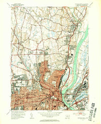 1952 Hartford North1954 Print · USGSGreater Hartford is depicted in the early fifties as the city expanded across the river into the surrounding suburbs. Genealogists can trace family footprints through numerous urban cemeteries like Mt St Benedict Cemetery and historic institutions including Trinity College and St Thomas Seminary.3 unique versions available
 - 1952 Map of Manchester, 1954 Print
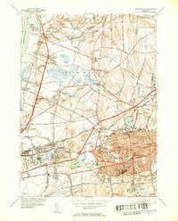 1952 Manchester1954 Print · USGSManchester and the surrounding river valleys are captured here during the post-war growth of the early fifties. Genealogists and local historians can locate several family landmarks including Rye Street Cem, Talcottville, and the Nathan Hale Sch.3 unique versions available
 - 1953 Map of Windsor Locks, 1954 Print
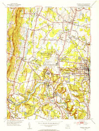 1953 Windsor Locks1954 Print · USGSThe Connecticut River valley comes alive in the early fifties, centered on the growing aviation hub at Bradley Field. Genealogists can trace family roots through West Suffield Cem, Suffield Academy, and the historic grounds of Newgate Prison.3 unique versions available
 - 1953 Map of Broad Brook, 1954 Print
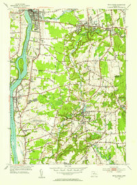 1953 Broad Brook1954 Print · USGSHartford County's agricultural and industrial character is preserved here just after the war, showing the village centers of Broad Brook and Hazardville. Researchers can locate old family plots at St Patricks Cem, trace the local water power at Sadds Mill, or find the former site of the Wallop Sch.4 unique versions available
End of results
Showing maps 1-4 of 4
Top cities near Windsor
- Springfield historical maps
- Hartford historical maps
- New Britain historical maps
- West Hartford historical maps
- Bristol historical maps
- Manchester historical maps
See more
Top neighborhoods of Windsor
- Birchwood historical maps
- Hayden historical maps
- Wilson historical maps
- Breakneck historical maps
- Rainbow historical maps
- Poquonock historical maps
See more
Frequently asked questions
- What are the different types of historical maps available for Windsor?
- What is the oldest map of Windsor?
- Where can I purchase historical maps of Windsor for my home or office?
- Where can I download high-res historical maps of Windsor?
- Are there historical topographic maps available for Windsor?
- Is there historical aerial imagery available for Windsor?
- Where are historical maps of Windsor sourced from?