1950s Maps of East Haddam, Connecticut
Explore 4 historic maps of East Haddam from the 1950s. These maps offer a rare glimpse into what life looked like during the 1950s — showing old roads, neighborhoods, homes, and landmarks that have changed or disappeared over time.
Whether you're researching your family's past, planning a metal detecting trip, or studying how East Haddam's landscape evolved across the 1950s, these high-resolution maps are a powerful tool for exploring the history of this region.
- Focus on a specific era: All maps on this page are from the 1950s, giving you a focused view of this time period.
- See what’s changed: Compare century-old streets, trails, and buildings to today's modern landscape using overlays and satellite layers.
- Research with precision: Use these maps for genealogy, historical research, land use analysis, or educational projects.
- View, download, or print: Maps are fully viewable online in high resolution, and can be downloaded or printed for your own records.
Start exploring East Haddam's history through authentic maps from the 1950s. This is your window into the past.
East Haddam, CT maps
(4)- 1952 Map of Deep River, 1953 Print
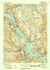 1952 Deep River1953 Print · USGSMiddlesex County life in the early fifties is centered on the river and rail lines between Moodus and Deep River. Genealogists and historians can trace family roots through numerous local landmarks like Hearse Hill Cem, Parker Cem, and Johnson Mill.3 unique versions available
 - 1952 Map of Moodus, 1953 Print
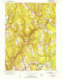 1952 Moodus1953 Print · USGSThe Moodus area in the early fifties shows a landscape defined by industrial river power and maturing state forests. Genealogists and hikers can trace historic connections between Moodus, Leesville, and the Old Comstock Bridge while locating family plots at Bashan Lake Cem.3 unique versions available
 - 1952 Map of Hamburg, 1954 Print
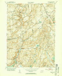 1952 Hamburg1954 Print · USGSIn the early 1950s, this pocket of New London County remained a landscape of dense state forests and scattered farmsteads. Researchers can trace numerous family burial sites like Millington Cem or explore the grounds of the Yale Engineering Camp and Devils Hopyard State Park.3 unique versions available
 - 1953 Map of Colchester, 1954 Print
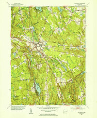 1953 Colchester1954 Print · USGSColchester and its surrounding hamlets are captured in the early 1950s, revealing a landscape of historic crossroads and family-named corners. Genealogists can trace ancestral locations at St Johns Cem, Exeter Ch, and rural intersections like Avery Corner.7 unique versions available
End of results
Showing maps 1-4 of 4
Top cities near East Haddam
- Middletown historical maps
- Glastonbury historical maps
- Wethersfield historical maps
- Windham historical maps
- Southold historical maps
- Montville historical maps
See more
Top neighborhoods of East Haddam
- Mount Parnassus historical maps
- Bashan historical maps
- Goodspeeds Landing historical maps
- Haywardville historical maps
- Leesville historical maps
- Bailey Beach historical maps
See more
Frequently asked questions
- What are the different types of historical maps available for East Haddam?
- What is the oldest map of East Haddam?
- Where can I purchase historical maps of East Haddam for my home or office?
- Where can I download high-res historical maps of East Haddam?
- Are there historical topographic maps available for East Haddam?
- Is there historical aerial imagery available for East Haddam?
- Where are historical maps of East Haddam sourced from?