1950s Maps of Middlebury, Connecticut
Explore 6 historic maps of Middlebury from the 1950s. These maps offer a rare glimpse into what life looked like during the 1950s — showing old roads, neighborhoods, homes, and landmarks that have changed or disappeared over time.
Whether you're researching your family's past, planning a metal detecting trip, or studying how Middlebury's landscape evolved across the 1950s, these high-resolution maps are a powerful tool for exploring the history of this region.
- Focus on a specific era: All maps on this page are from the 1950s, giving you a focused view of this time period.
- See what’s changed: Compare century-old streets, trails, and buildings to today's modern landscape using overlays and satellite layers.
- Research with precision: Use these maps for genealogy, historical research, land use analysis, or educational projects.
- View, download, or print: Maps are fully viewable online in high resolution, and can be downloaded or printed for your own records.
Start exploring Middlebury's history through authentic maps from the 1950s. This is your window into the past.
Middlebury, CT maps
(6)- 1950 Map of Woodbury
 1950 Woodbury1950 Print · USGSWoodbury and Watertown are captured in the late 1940s, showing a Connecticut landscape of river valleys and institutional landmarks. Researchers can trace historic cemeteries like North Cem and school grounds such as Taft Sch near Lake Quassapaug.2 unique versions available
 - 1951 Map of Waterbury
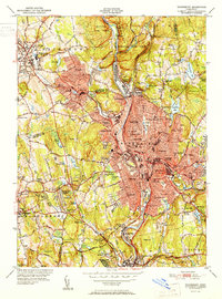 1951 Waterbury1951 Print · USGSMid-century New Haven County is captured here at a moment of dense urban growth and industrial activity along the Naugatuck River. Genealogists and researchers can pinpoint family landmarks from Riverside Cemetery to the Brookside Home for the Aged and numerous parochial and public schools.2 unique versions available
 - 1953 Map of Southbury, 1956 Print
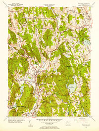
 1953 Southbury1956 Print · USGSThe Housatonic valley in the early fifties shows a landscape transitioning between rural life and riverfront recreation. Genealogists can locate family names at Pine Hill Cem and Jacks Hill Cem or trace the early bounds of Kettletown State Park.3 unique versions available
 - 1954 Map of Naugatuck, 1956 Print
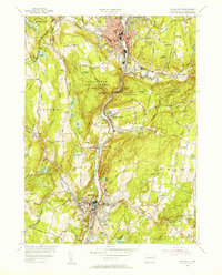 1954 Naugatuck1956 Print · USGSThe Naugatuck Valley is shown at a mid-century industrial peak, with neighborhoods and factories clustered along the Naugatuck River. Genealogists can trace family footprints through numerous local institutions like Tuttle Sch, St James Cem, and the old rail stops at Union City.3 unique versions available
 - 1955 Map of Woodbury, 1956 Print
 1955 Woodbury1956 Print · USGSMid-century Woodbury and its surrounding hills appear here during a period of steady growth along the Pomperaug River. Researchers can trace old family sites and local landmarks like Regina Laudis Priory, Lake Quassapaug, and the Taft Sch.5 unique versions available
 - 1955 Map of Waterbury, 1957 Print
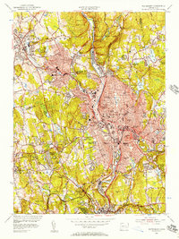 1955 Waterbury1957 Print · USGSWaterbury and the Naugatuck Valley are shown here during a period of significant post-war growth and industrial activity. Researchers can trace historic institutions and neighborhoods from Riverside Cemetery to the Taft Sch and the New York New Haven and Hartford RR corridor.2 unique versions available
End of results
Showing maps 1-6 of 6
Top cities near Middlebury
- New Haven historical maps
- Waterbury historical maps
- Bristol historical maps
- Hamden historical maps
- West Haven historical maps
- Southington historical maps
See more
Top neighborhoods of Middlebury
- Hillcrest historical maps
- Westview Heights historical maps
- Bradleyville historical maps
- Oronoke historical maps
- Middlebury Center Historic District historical maps
Frequently asked questions
- What are the different types of historical maps available for Middlebury?
- What is the oldest map of Middlebury?
- Where can I purchase historical maps of Middlebury for my home or office?
- Where can I download high-res historical maps of Middlebury?
- Are there historical topographic maps available for Middlebury?
- Is there historical aerial imagery available for Middlebury?
- Where are historical maps of Middlebury sourced from?