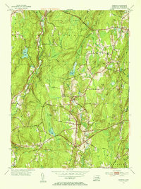
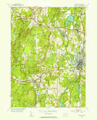
Old Maps of Canterbury, Connecticut for Genealogy
Trace your family roots with 56 historic maps of Canterbury. These high-res maps reveal old neighborhoods, homesites, landmarks, and streets — helping you uncover where your ancestors lived and how the area evolved over time.
- Explore historic neighborhoods: Identify where your relatives may have lived in the 1800s or 1900s.
- Compare maps over time: Trace the changes in streets, buildings, and landmarks for multi-generational research.
- Perfect for genealogy & ancestry research: Used by family historians and researchers to map out lineage and migration.
These maps are an incredible resource for exploring your personal connection to Canterbury's past.
Canterbury, CT maps
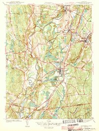
(56)- 1889 Map of Putnam
 1889 Putnam1889 Print · USGSThe industrial Quinebaug Valley comes alive in the late 1880s, showcasing a landscape of riverside mill towns and critical rail junctions. Genealogists can trace family roots through specific locales like Danielsonville, Putnam Heights P.O., and Thompson Station.
 - 1889 Map of Moosup
 1889 Moosup1889 Print · USGSThe Connecticut-Rhode Island borderlands were a hive of rail activity and river power in the late nineteenth century. You can trace early transit routes through Plainfield Junction or locate rural landmarks like Moosup Valley P.O. and Sterling Station.
 - 1892 Map of Woodstock
 1892 Woodstock1892 Print · USGSNortheastern Connecticut at the close of the nineteenth century was a landscape of river-powered mill villages and independent farmsteads. Genealogists and historians can trace the paths between Mansfield Center, Phoenixville, and the New York and New England Railroad stops.6 unique versions available
 - 1892 Map of Norwich
 1892 Norwich1892 Print · USGSEastern Connecticut's industrial heartland is documented here in the late nineteenth century, showing the critical junction of the Thames, Shetucket, and Yantic rivers. Genealogists and historians can trace the early layouts of manufacturing hubs like Norwich and Willimantic alongside smaller settlements such as Bozrahville and Versailles.8 unique versions available
 - 1893 Map of Putnam
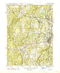
 1893 Putnam1893 Print · USGSNortheastern Connecticut and the Rhode Island borderlands are documented here in the 1890s as the rail-and-river economy reached its peak. Researchers can trace historic mill villages like Ballouville, follow the New York and New England Railroad, or locate family sites near Danielsonville.8 unique versions available
 - 1893 Map of Moosup
 1893 Moosup1893 Print · USGSEastern Connecticut and western Rhode Island meet here in the late nineteenth century at a peak of rail-driven industry. Genealogists can trace family footprints through historic hubs like Jewett City, Hopkins Hollow, and the mills surrounding Pachaug Pond.7 unique versions available
 - 1919 Map of Putnam
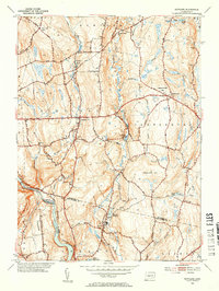
 1919 Putnam1919 Print · USGSWindham County and the Rhode Island borderlands are captured here during a period of heavy rail reliance and mill town growth. Researchers can trace the New York and New England Railroad through Pomfret Station or locate local landmarks like Cooke Store and Poutis Landing.
 - 1920 Map of Moosup
 1920 Moosup1920 Print · USGSEastern Connecticut and the Rhode Island border were thriving hubs of textile milling and rail transit just after the Great War. Genealogists and local historians can trace family-named locations such as Hopkins Hollow, industrial sites like Sterling Station, and the intricate rail network at Plainfield Junction.
 - 1921 Map of Woodstock
 1921 Woodstock1921 Print · USGSWindham County villages and highland ridges are captured here during the early twentieth century, showing a landscape of small mill towns and glacial ponds. Researchers can trace the path of the New York New Haven and Hartford Railroad or locate family roots in Atwoodville, Phoenixville, or Mansfield Hollow.
 - 1943 Map of Plainfield
 1943 Plainfield1943 Print · USGSWindham County at the height of the Second World War shows a landscape shaped by mill villages and steam-era rail lines. Genealogists and local historians can trace family locations near Plainfield Cem, Frost Sch, and the textile hubs of Wauregan and Moosup.3 unique versions available
 - 1943 Map of Putnam, 1944 Print
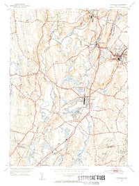
 1943 Putnam1944 Print · USGSThe Connecticut and Rhode Island borderlands are captured here during the wartime era, showing a landscape defined by textile river towns and sprawling state forests. Trace the industrial rail corridor of the New York New Haven and Hartford through Putnam, Danielson, and Moosup.
 - 1944 Map of Hampton
 1944 Hampton1944 Print · USGSWindham County during the mid-forties reveals a rural Connecticut landscape of rail-connected villages and state forest land. Trace the path of the New York New Haven and Hartford railroad to find Hampton Sta, the Elliotts Sch, and the North Cem.2 unique versions available
 - 1946 Map of Danielson
 1946 Danielson1946 Print · USGSMid-century Windham County is shown here during a period of industrial transition along the Quinebaug River. Local historians can trace the rail-side developments of Goodyear and Danielson, find the State Orphanage, or locate old landmarks like the Creamery and Pomfret Sta.2 unique versions available
 - 1946 Map of Scotland
 1946 Scotland1946 Print · USGSScotland and the surrounding Windham County highlands are shown here in the mid-1940s as a landscape of small villages and ancestral farms. Genealogists can locate family sites near Scotland Cem, Howard Valley Ch, and the New York New Haven and Hartford rail line.
 - 1947 Map of Providence, 1948 Print
 1947 Providence1948 Print · USGSSouthern New England is captured in the mid-1940s, showing a landscape defined by busy industrial ports and expanding military installations. Researchers can trace the rail lines of the N.Y. N.H. & H. RR or locate coastal defenses like Fort Adams and Quonset Point.5 unique versions available
 - 1947 Map of Hartford, 1955 Print
 1947 Hartford1955 Print · USGSSouthern New England and the Hudson Valley are shown in detail during the post-war expansion era. Genealogists and researchers can trace local landmarks from the State Capitol and Yale University to the Stratford Lighthouse and Woodlawn Cem.2 unique versions available
 - 1948 Map of Hartford
 1948 Hartford1948 Print · USGSSouthern New England is captured here in the late 1940s, showcasing a landscape of thriving industrial cities and developing parkways. Genealogists and historians can trace the rail networks of the New York New Haven and Hartford RR or locate coastal defense sites like Fort Terry and Camp Shanks.2 unique versions available
 - 1948 Map of Providence, 1951 Print
 1948 Providence1951 Print · USGSSouthern New England’s coastal reaches are captured here in the late 1940s, from the industrial heart of Providence to the tip of Provincetown. Genealogists and historians can trace rail lines like the Central Vermont Railway and locate active military sites such as Otis Air Force Base and Fort Rodman.
 - 1953 Map of Scotland, 1954 Print
 1953 Scotland1954 Print · USGSWindham County at mid-century reveals a network of small settlements and river-powered landscapes along the Shetucket River. Genealogists and historians can trace family-named sites like Pudding Hill, the Howard Valley Church, and old burial grounds including Scotland Cem.5 unique versions available
 - 1953 Map of Plainfield, 1955 Print
 1953 Plainfield1955 Print · USGSWindham County villages are shown in detail during the early 1950s as industry and rail networks still defined the valley. Genealogists can locate family plots at Evergreen Cem and St Johns Cem, or trace the rail sidings at Wauregan Sta.6 unique versions available
 - 1953 Map of Hampton, 1955 Print
 1953 Hampton1955 Print · USGSWindham County in the mid-fifties is a landscape of established hill towns and rail-connected hamlets. Genealogists and historians can trace family locations through Elliotts School, local burial sites like Litchfield Cemetery, and the path of the New York New Haven and Hartford line.5 unique versions available
 - 1955 Map of Danielson, 1956 Print
 1955 Danielson1956 Print · USGSEastern Connecticut towns and industrial villages thrive along the Quinebaug River and railroad in the mid-fifties. Trace the development of Danielson and Brooklyn while locating landmarks like Putnam Wolf Den and the Sacred Heart Convent.7 unique versions available
 - 1957 Map of Providence
 1957 Providence1957 Print · USGSCoastal New England at the height of the mid-century era shows a landscape shaped by maritime industry and Cold War defense. Genealogists and historians can trace the reach of the New York, New Haven & Hartford RR and locate legacy sites like Fort Adams and Quonset Point Naval Air Station.
 - 1958 Map of Providence
 1958 Providence1958 Print · USGSThe Rhode Island and Massachusetts coastlines are shown in detail during the late 1950s, from the urban cores to the tips of the islands. Researchers can trace the mid-century footprint of Quonset Point Naval Air Station, the defense works at Fort Adams, and the rail network of the New York, New Haven and Hartford RR.
 - 1961 Map of Hartford
 1961 Hartford1961 Print · USGSSouthern New England and the Hudson Valley are shown here in the mid-fifties, capturing a landscape of booming coastal cities and interior hill towns. Researchers can trace the legacy of the New York New Haven and Hartford rail corridor and find strategic sites like Camp Shanks and Fort Michie.
Showing maps 1-25 of 56
Top cities near Canterbury
- Norwich historical maps
- Coventry historical maps
- Mansfield historical maps
- Windham historical maps
- Montville historical maps
- Killingly historical maps
See more
Top neighborhoods of Canterbury
- Westminster historical maps
- Packerville historical maps
- Canterbury Center Historic District historical maps
Frequently asked questions
- What are the different types of historical maps available for Canterbury?
- What is the oldest map of Canterbury?
- Where can I purchase historical maps of Canterbury for my home or office?
- Where can I download high-res historical maps of Canterbury?
- Are there historical topographic maps available for Canterbury?
- Is there historical aerial imagery available for Canterbury?
- Where are historical maps of Canterbury sourced from?