1950s Maps of Chaplin, Connecticut
Explore 4 historic maps of Chaplin from the 1950s. These maps offer a rare glimpse into what life looked like during the 1950s — showing old roads, neighborhoods, homes, and landmarks that have changed or disappeared over time.
Whether you're researching your family's past, planning a metal detecting trip, or studying how Chaplin's landscape evolved across the 1950s, these high-resolution maps are a powerful tool for exploring the history of this region.
- Focus on a specific era: All maps on this page are from the 1950s, giving you a focused view of this time period.
- See what’s changed: Compare century-old streets, trails, and buildings to today's modern landscape using overlays and satellite layers.
- Research with precision: Use these maps for genealogy, historical research, land use analysis, or educational projects.
- View, download, or print: Maps are fully viewable online in high resolution, and can be downloaded or printed for your own records.
Start exploring Chaplin's history through authentic maps from the 1950s. This is your window into the past.
Chaplin, CT maps
(4)- 1953 Map of Willimantic, 1954 Print
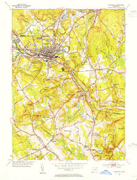 1953 Willimantic1954 Print · USGSWillimantic and its surrounding hill country are captured here in the early fifties, showing a bustling rail junction at the height of its mid-century character. Trace the routes of the Central Vermont Railway, find the historic Trumbull Cem, or locate the old Willimantic State Teachers College.5 unique versions available
 - 1953 Map of Scotland, 1954 Print
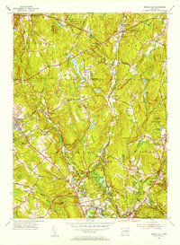
 1953 Scotland1954 Print · USGSWindham County at mid-century reveals a network of small settlements and river-powered landscapes along the Shetucket River. Genealogists and historians can trace family-named sites like Pudding Hill, the Howard Valley Church, and old burial grounds including Scotland Cem.5 unique versions available
 - 1953 Map of Spring Hill, 1955 Print
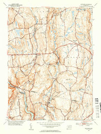
 1953 Spring Hill1955 Print · USGSTolland and Windham counties are shown in the early fifties as the University of Connecticut expanded within a landscape of traditional hill towns. Trace ancestral roots through rural landmarks like Wormwood Hill Cem, the crossroads at Bedlam Corner, and the old rail line at North Windham.4 unique versions available
 - 1953 Map of Hampton, 1955 Print
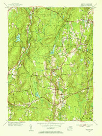 1953 Hampton1955 Print · USGSWindham County in the mid-fifties is a landscape of established hill towns and rail-connected hamlets. Genealogists and historians can trace family locations through Elliotts School, local burial sites like Litchfield Cemetery, and the path of the New York New Haven and Hartford line.5 unique versions available
End of results
Showing maps 1-4 of 4
Top cities near Chaplin
- Norwich historical maps
- Mansfield historical maps
- Windham historical maps
- Willimantic historical maps
- Killingly historical maps
- Storrs historical maps
See more
Top neighborhoods of Chaplin
- Bedlam Corner historical maps
- South Chaplin historical maps
- Sherman Corner historical maps
- Chaplin Historic District historical maps
Frequently asked questions
- What are the different types of historical maps available for Chaplin?
- What is the oldest map of Chaplin?
- Where can I purchase historical maps of Chaplin for my home or office?
- Where can I download high-res historical maps of Chaplin?
- Are there historical topographic maps available for Chaplin?
- Is there historical aerial imagery available for Chaplin?
- Where are historical maps of Chaplin sourced from?