1980s Maps of Chaplin, Connecticut
Explore 5 historic maps of Chaplin from the 1980s. These maps offer a rare glimpse into what life looked like during the 1980s — showing old roads, neighborhoods, homes, and landmarks that have changed or disappeared over time.
Whether you're researching your family's past, planning a metal detecting trip, or studying how Chaplin's landscape evolved across the 1980s, these high-resolution maps are a powerful tool for exploring the history of this region.
- Focus on a specific era: All maps on this page are from the 1980s, giving you a focused view of this time period.
- See what’s changed: Compare century-old streets, trails, and buildings to today's modern landscape using overlays and satellite layers.
- Research with precision: Use these maps for genealogy, historical research, land use analysis, or educational projects.
- View, download, or print: Maps are fully viewable online in high resolution, and can be downloaded or printed for your own records.
Start exploring Chaplin's history through authentic maps from the 1980s. This is your window into the past.
Chaplin, CT maps
(5)- 1983 Map of Spring Hill
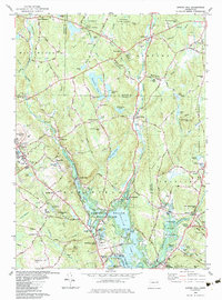 1983 Spring Hill1983 Print · USGSTolland and Windham Counties are captured here in the early 1980s, centered on the growing campus at Storrs. Researchers can trace the layout of Mansfield Center, locate the Old Mansfield Cem, or follow the Nipmuck Trail through the valley.3 unique versions available
 - 1983 Map of Scotland, 1984 Print
 1983 Scotland1984 Print · USGSWindham County and the surrounding uplands are captured in the early 1980s as a landscape of rural hamlets and protected forests. Researchers can trace local genealogy and land use through features like Palmertown Cem, Potash Hill Road, and the village of Hanover.
 - 1984 Map of Willimantic
 1984 Willimantic1984 Print · USGSWillimantic and the surrounding towns of Windham and Lebanon are shown here during the mid-1980s, revealing a landscape shaped by river junctions and rail history. Genealogists can trace family names at Liberty Hill Cem or locate the historic Willimantic Camp Ground and Lyman Mem Sch.
 - 1984 Map of Hampton
 1984 Hampton1984 Print · USGSWindham County in the early eighties remains a landscape of deep forests and quiet crossroads. Researchers can trace historic family burial sites at Chewink Cem and North Cem or locate former hubs like Clarks Corner and Stetson Corner.
 - 1986 Map of Hartford
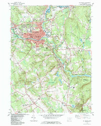
 1986 Hartford1986 Print · USGSCentral Connecticut and the surrounding highlands were undergoing significant suburban growth and industrial transition during the mid-eighties. Researchers can trace the layout of regional landmarks including Bradley International Airport, the University of Connecticut, and the historic State Capitol.
End of results
Showing maps 1-5 of 5
Top cities near Chaplin
- Norwich historical maps
- Mansfield historical maps
- Windham historical maps
- Willimantic historical maps
- Killingly historical maps
- Storrs historical maps
See more
Top neighborhoods of Chaplin
- Bedlam Corner historical maps
- South Chaplin historical maps
- Sherman Corner historical maps
- Chaplin Historic District historical maps
Frequently asked questions
- What are the different types of historical maps available for Chaplin?
- What is the oldest map of Chaplin?
- Where can I purchase historical maps of Chaplin for my home or office?
- Where can I download high-res historical maps of Chaplin?
- Are there historical topographic maps available for Chaplin?
- Is there historical aerial imagery available for Chaplin?
- Where are historical maps of Chaplin sourced from?