1980s Maps of Voluntown, Connecticut
Explore 3 historic maps of Voluntown from the 1980s. These maps offer a rare glimpse into what life looked like during the 1980s — showing old roads, neighborhoods, homes, and landmarks that have changed or disappeared over time.
Whether you're researching your family's past, planning a metal detecting trip, or studying how Voluntown's landscape evolved across the 1980s, these high-resolution maps are a powerful tool for exploring the history of this region.
- Focus on a specific era: All maps on this page are from the 1980s, giving you a focused view of this time period.
- See what’s changed: Compare century-old streets, trails, and buildings to today's modern landscape using overlays and satellite layers.
- Research with precision: Use these maps for genealogy, historical research, land use analysis, or educational projects.
- View, download, or print: Maps are fully viewable online in high resolution, and can be downloaded or printed for your own records.
Start exploring Voluntown's history through authentic maps from the 1980s. This is your window into the past.
Voluntown, CT maps
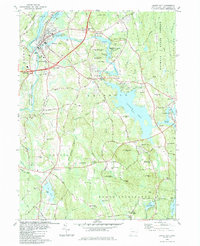
(3)- 1983 Map of Plainfield
 1983 Plainfield1983 Print · USGSThe Quinebaug River valley in the early eighties shows a landscape of industrial mill towns and expanding state forests. Trace local history through landmarks like Wauregan Station, Plainfield Greyhound Park, and several family cemeteries including Baldwin Cemetery.3 unique versions available
 - 1984 Map of Jewett City
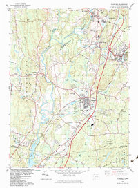
 1984 Jewett City1984 Print · USGSJewett City and the surrounding Griswold hills appear in the mid-1980s as a landscape defined by its river-driven industry and deep woods. Researchers can trace family sites at Geer Cem or locate old crossings near Doaneville and the Pachaug Pond shoreline.3 unique versions available
 - 1984 Map of Providence, 1985 Print
 1984 Providence1985 Print · USGSThe Rhode Island coast and its industrial heartlands are captured here in the mid-eighties, showing the density of the Providence metro area. Researchers can trace historic rail lines like the Providence & Worcester RR and explore the maritime layout of Narragansett Bay and Newport.
End of results
Showing maps 1-3 of 3
Top cities near Voluntown
- Norwich historical maps
- Groton historical maps
- Coventry historical maps
- South Kingstown historical maps
- New London historical maps
- Westerly historical maps
See more
Top neighborhoods of Voluntown
Frequently asked questions
- What are the different types of historical maps available for Voluntown?
- What is the oldest map of Voluntown?
- Where can I purchase historical maps of Voluntown for my home or office?
- Where can I download high-res historical maps of Voluntown?
- Are there historical topographic maps available for Voluntown?
- Is there historical aerial imagery available for Voluntown?
- Where are historical maps of Voluntown sourced from?