Old Maps of Kent, Connecticut for Metal Detecting
Plan your next treasure hunt with 49 historic maps of Kent. Find old homesites, ghost towns, trails, and gathering spots that may be lost to time — perfect for identifying promising metal detecting locations.
- Locate forgotten sites: Uncover places like long-lost settlements, abandoned rail lines, or gathering spots.
- Plan better hunts: Use map overlays combined with LiDAR or satellite views to narrow in on historically rich areas.
- Made for detectorists: Thousands of hobbyists use these maps to discover relics, coins, and hidden history.
Use these historic maps to boost your research and find new opportunities beneath the surface of Kent.
Kent, CT maps
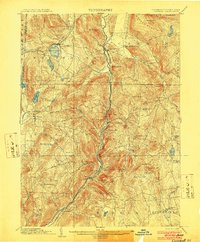
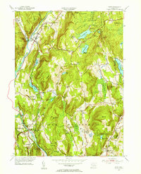
(49)- 1892 Map of Cornwall
 1892 Cornwall1892 Print · USGSLitchfield County in the 1890s reveals a landscape of river-powered industry and rail-connected villages. Researchers can trace ancestral roots and old transport routes through Ore Hill, Lime Rock, and the stops along the Housatonic Railroad.
 - 1892 Map of New Milford
 1892 New Milford1892 Print · USGSLitchfield County in the late nineteenth century is defined by the steep valleys of the Housatonic and Shepaug rivers. Genealogists and researchers can trace the rail-and-river economy through landmarks like Housatonic Railroad, Boardmans Bridge, and Washington Green.
 - 1893 Map of New Milford
 1893 New Milford1893 Print · USGSLitchfield County's river valleys and hills are captured here in the late nineteenth century, showing the region's development before modern expansion. Genealogists can trace the rail-and-river network through historic depots like Merwinsville and old village centers including Washington Green and Bridgewater.2 unique versions available
 - 1893 Map of Cornwall
 1893 Cornwall1893 Print · USGSLitchfield County's iron-mining and rail-corridor history comes into focus in the 1890s as the Housatonic Railroad follows the river valley. Genealogists and historians can trace old property lines and rural centers like Ore Hill, Lime Rock, and Amenia Union.3 unique versions available
 - 1893 Map of Clove
 1893 Clove1893 Print · USGSDutchess County and the Connecticut border come to life in the 1890s, when iron furnaces and rural depots still defined the landscape. Trace the tracks of the Columbia and Clove R.R. and find old family landmarks like Crouse Store and Moore Mill.
 - 1894 Map of Clove
 1894 Clove1894 Print · USGSDutchess County at the close of the nineteenth century was a land of steep ridges and vital rail corridors. Genealogists and local historians can trace family locations near Dover Furnace, Clove Valley, and rural landmarks like Crouse Store.
 - 1898 Map of Clove
 1898 Clove1898 Print · USGSDutchess County and the Connecticut borderlands are captured here in the late nineteenth century as railroads fueled the growth of valley towns. Genealogists and historians can trace family locations in Verbank Village, Stormville, and near landmarks like Bulls Bridge.
 - 1899 Map of Millbrook, 1956 Print
 1899 Millbrook1956 Print · USGSDutchess County enters a period of high rail connectivity in the late nineteenth century, as iron and agriculture drive local growth. Genealogists and historians can trace the paths of four railroads through hamlets like Millerton, Bangall, and Amenia Union.
 - 1901 Map of Clove
 1901 Clove1901 Print · USGSDutchess County and the Connecticut borderlands are captured here at the close of the nineteenth century as the rail corridors began to shape local commerce. Genealogists can trace family holdings and old junctions from Dover Plains to Stormville and Moores Mill.11 unique versions available
 - 1902 Map of Millbrook
 1902 Millbrook1902 Print · USGSEastern Dutchess County at the turn of the century was a bustling corridor of intersecting railroads and valley settlements. Genealogists and rail historians can trace the paths of the Central New England R. R. and find local landmarks like Lithgow, Shekomeko, and Hammertown.10 unique versions available
 - 1903 Map of Cornwall
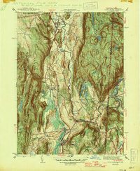
 1903 Cornwall1903 Print · USGSNorthwestern Connecticut at the dawn of the twentieth century shows a landscape of iron-mining hamlets and river-valley rail lines. Genealogists and historians can trace the foundations of Ore Hill, the streets of Salisbury, and the path of the Central New England RR.9 unique versions available
 - 1904 Map of New Milford
 1904 New Milford1904 Print · USGSLitchfield County at the close of the nineteenth century is defined by the industrial valleys of the Housatonic River and the rural reaches of Washington. Researchers can trace the era's infrastructure through landmarks like Kent Furnace, the Berkshire Division rail line, and the village at Roxbury Station.8 unique versions available
 - 1904 Map of Litchfield
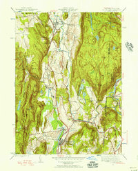
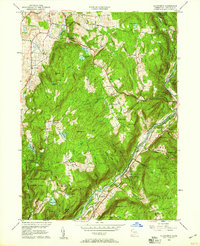
 1904 Litchfield1904 Print · USGSThe Litchfield Hills at the turn of the century are shown here as a landscape of iron heritage and river-powered industry. Genealogists and historians can locate old industrial sites like Kent Furnace, ancestral homes near Sharon Valley, and early rail stops at Limerock Sta..3 unique versions available
 - 1944 Map of Dover Plains, 1956 Print
 1944 Dover Plains1956 Print · USGSDutchess County at the close of the Second World War was a landscape of fertile valleys and mountain ridges. Genealogists and historians can trace rail-side life and local landmarks like Dover Plains, the Appalachian Trail, and the Schaghticoke Indian Reservation.2 unique versions available
 - 1947 Map of Dover Plains
 1947 Dover Plains1947 Print · USGSDutchess County at the edge of the Connecticut border reveals a landscape of state institutions, mountain ridges, and river valleys in the late 1940s. Genealogists can trace family landmarks like Valley View Cem or search for old schoolhouses including Dover Furnace Sch and Webatuck Sch.2 unique versions available
 - 1947 Map of Hartford, 1955 Print
 1947 Hartford1955 Print · USGSSouthern New England and the Hudson Valley are shown in detail during the post-war expansion era. Genealogists and researchers can trace local landmarks from the State Capitol and Yale University to the Stratford Lighthouse and Woodlawn Cem.2 unique versions available
 - 1948 Map of Hartford
 1948 Hartford1948 Print · USGSSouthern New England is captured here in the late 1940s, showcasing a landscape of thriving industrial cities and developing parkways. Genealogists and historians can trace the rail networks of the New York New Haven and Hartford RR or locate coastal defense sites like Fort Terry and Camp Shanks.2 unique versions available
 - 1950 Map of Kent
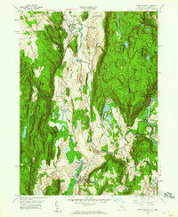
 1950 Kent1950 Print · USGSWestern Connecticut's river valleys and ridgelines are captured here at mid-century, following the winding Housatonic River. Researchers can trace the New York New Haven and Hartford RR through Gaylordsville or locate Bulls Bridge and Kent Furnace.2 unique versions available
 - 1950 Map of Ellsworth
 1950 Ellsworth1950 Print · USGSLitchfield County's upland farms and river valleys are captured here at the mid-century, before the post-war era transformed the Connecticut countryside. Genealogists and hikers can trace the Appalachian Trail across Calebs Peak or locate family plots at Skiff Mtn Cem and Calhoun Cem.2 unique versions available
 - 1955 Map of Kent, 1956 Print
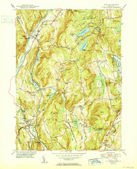
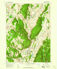
 1955 Kent1956 Print · USGSLitchfield County in the mid-fifties is a landscape of river-valley towns and upland summer camps. Genealogists and historians can trace rail-era landmarks like Gaylordsville Sta and old burial grounds such as Kent Hollow Cem or Morningside Cem.4 unique versions available
 - 1956 Map of Ellsworth, 1958 Print
 1956 Ellsworth1958 Print · USGSLitchfield County's upland farms and river valleys appear here in the mid-twentieth century as the regional landscape balanced conservation and industry. Genealogists can locate several remote burial sites like Skiff Mtn Cem or trace the early route of the Appalachian Trail near North Kent.5 unique versions available
 - 1958 Map of Amenia, 1959 Print
 1958 Amenia1959 Print · USGSDutchess County in the late fifties shows a rural landscape anchored by the New York Central Railroad and several historic hamlets. Researchers can trace the layout of the Wassaic State School or locate family sites near the Stone Church and Millbrook Cem.5 unique versions available
 - 1958 Map of Dover Plains, 1960 Print
 1958 Dover Plains1960 Print · USGSDutchess County enters the late fifties with its rail-and-river corridor well-established between Dover Plains and Wingdale. Genealogists and hikers can trace the Appalachian Trail past the Schaghticoke Indian Reservation and locate landmarks like Dover Furnace and the Valley View Cem.4 unique versions available
 - 1961 Map of Hartford
 1961 Hartford1961 Print · USGSSouthern New England and the Hudson Valley are shown here in the mid-fifties, capturing a landscape of booming coastal cities and interior hill towns. Researchers can trace the legacy of the New York New Haven and Hartford rail corridor and find strategic sites like Camp Shanks and Fort Michie.
 - 1962 Map of Hartford, 1971 Print
 1962 Hartford1971 Print · USGSSouthern New England and the Hudson Valley are shown in the early sixties, as suburban growth reached into the foothills. Trace the path of the New York New Haven & Hartford RR and find landmarks like Camp Nathan Hale and Gillette Castle State Park.3 unique versions available
Showing maps 1-25 of 49
Top cities near Kent
- East Fishkill historical maps
- Southbury historical maps
- Brookfield historical maps
- New Fairfield historical maps
- Beekman historical maps
- Kent historical maps
See more
Top neighborhoods of Kent
- East Kent historical maps
- Flanders historical maps
- Kent Furnace historical maps
- South Kent historical maps
- Macedonia historical maps
- Bulls Bridge historical maps
See more
Frequently asked questions
- What are the different types of historical maps available for Kent?
- What is the oldest map of Kent?
- Where can I purchase historical maps of Kent for my home or office?
- Where can I download high-res historical maps of Kent?
- Are there historical topographic maps available for Kent?
- Is there historical aerial imagery available for Kent?
- Where are historical maps of Kent sourced from?