1950s Maps of West Woods, Sharon
Explore 2 historic maps of West Woods from the 1950s. These maps offer a rare glimpse into what life looked like during the 1950s — showing old roads, neighborhoods, homes, and landmarks that have changed or disappeared over time.
Whether you're researching your family's past, planning a metal detecting trip, or studying how West Woods's landscape evolved across the 1950s, these high-resolution maps are a powerful tool for exploring the history of this region.
- Focus on a specific era: All maps on this page are from the 1950s, giving you a focused view of this time period.
- See what’s changed: Compare century-old streets, trails, and buildings to today's modern landscape using overlays and satellite layers.
- Research with precision: Use these maps for genealogy, historical research, land use analysis, or educational projects.
- View, download, or print: Maps are fully viewable online in high resolution, and can be downloaded or printed for your own records.
Start exploring West Woods's history through authentic maps from the 1950s. This is your window into the past.
West Woods, Sharon maps
(2)- 1950 Map of Ellsworth
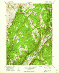
 1950 Ellsworth1950 Print · USGSLitchfield County's upland farms and river valleys are captured here at the mid-century, before the post-war era transformed the Connecticut countryside. Genealogists and hikers can trace the Appalachian Trail across Calebs Peak or locate family plots at Skiff Mtn Cem and Calhoun Cem.2 unique versions available
 - 1956 Map of Ellsworth, 1958 Print
 1956 Ellsworth1958 Print · USGSLitchfield County's upland farms and river valleys appear here in the mid-twentieth century as the regional landscape balanced conservation and industry. Genealogists can locate several remote burial sites like Skiff Mtn Cem or trace the early route of the Appalachian Trail near North Kent.5 unique versions available
End of results
Showing maps 1-2 of 2
Top cities near West Woods
- East Fishkill historical maps
- Beekman historical maps
- Woodbury historical maps
- Dover historical maps
- Litchfield historical maps
- Pawling historical maps
See more
Frequently asked questions
- What are the different types of historical maps available for West Woods?
- What is the oldest map of West Woods?
- Where can I purchase historical maps of West Woods for my home or office?
- Where can I download high-res historical maps of West Woods?
- Are there historical topographic maps available for West Woods?
- Is there historical aerial imagery available for West Woods?
- Where are historical maps of West Woods sourced from?