1950s Maps of East River, Madison
Explore 1 historic maps of East River from the 1950s. These maps offer a rare glimpse into what life looked like during the 1950s — showing old roads, neighborhoods, homes, and landmarks that have changed or disappeared over time.
Whether you're researching your family's past, planning a metal detecting trip, or studying how East River's landscape evolved across the 1950s, these high-resolution maps are a powerful tool for exploring the history of this region.
- Focus on a specific era: All maps on this page are from the 1950s, giving you a focused view of this time period.
- See what’s changed: Compare century-old streets, trails, and buildings to today's modern landscape using overlays and satellite layers.
- Research with precision: Use these maps for genealogy, historical research, land use analysis, or educational projects.
- View, download, or print: Maps are fully viewable online in high resolution, and can be downloaded or printed for your own records.
Start exploring East River's history through authentic maps from the 1950s. This is your window into the past.
East River, Madison maps
(1)- 1954 Map of Guilford, 1956 Print
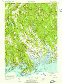 1954 Guilford1956 Print · USGSCoastal New Haven County is shown here in the mid-fifties, capturing the balance between the deep woods of the Cockaponset State Forest and the bustling Guilford shore. Genealogists and researchers can trace family landmarks like the Calvin Leete Sch or explore the jagged shoreline at Sachems Head and Stony Creek.4 unique versions available
End of results
Showing maps 1-1 of 1
Top cities near East River
- Brookhaven historical maps
- New Haven historical maps
- Meriden historical maps
- Hamden historical maps
- Middletown historical maps
- Wallingford historical maps
See more
Frequently asked questions
- What are the different types of historical maps available for East River?
- What is the oldest map of East River?
- Where can I purchase historical maps of East River for my home or office?
- Where can I download high-res historical maps of East River?
- Are there historical topographic maps available for East River?
- Is there historical aerial imagery available for East River?
- Where are historical maps of East River sourced from?