1930s Maps of East Lyme, Connecticut
Explore 4 historic maps of East Lyme from the 1930s. These maps offer a rare glimpse into what life looked like during the 1930s — showing old roads, neighborhoods, homes, and landmarks that have changed or disappeared over time.
Whether you're researching your family's past, planning a metal detecting trip, or studying how East Lyme's landscape evolved across the 1930s, these high-resolution maps are a powerful tool for exploring the history of this region.
- Focus on a specific era: All maps on this page are from the 1930s, giving you a focused view of this time period.
- See what’s changed: Compare century-old streets, trails, and buildings to today's modern landscape using overlays and satellite layers.
- Research with precision: Use these maps for genealogy, historical research, land use analysis, or educational projects.
- View, download, or print: Maps are fully viewable online in high resolution, and can be downloaded or printed for your own records.
Start exploring East Lyme's history through authentic maps from the 1930s. This is your window into the past.
East Lyme, CT maps
(4)- 1934 Map of Niantic
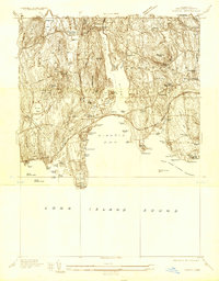 1934 Niantic1934 Print · USGSCoastal Connecticut in the 1930s reveals a landscape of growing beach colonies and significant state institutions. Genealogists and historians can trace family roots through Flanders Cem, or locate landmarks like the Seaside Connecticut State Sanatorium and the New York New Haven and Hartford Railroad.
 - 1935 Map of Montville
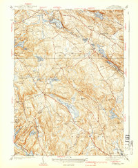
 1935 Montville1935 Print · USGSNew London County in the mid-thirties remains a landscape of tightly clustered villages, family-named hills, and critical water reserves. Local historians can trace early community life through sites like Chesterfield Cem, the Yale Engineering Camp, and schools such as Chapell Hill Sch and West Side Sch.
 - 1938 Map of Niantic
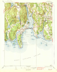 1938 Niantic1938 Print · USGSNiantic and East Lyme are captured here in the mid-1930s as the Connecticut shoreline evolved into a premier summer destination. Genealogists can locate family sites at Jordan Cem or St Marys Cem, while tracing the old Boston Post Road.3 unique versions available
 - 1939 Map of Montville
 1939 Montville1939 Print · USGSNew London County hills and valleys were a network of small mill ponds and upland farmsteads in the mid-1930s. Genealogists can trace family names at Raymond Hill Cem or locate rural landmarks like Chapel Hill Sch and the Central Vermont RR.3 unique versions available
End of results
Showing maps 1-4 of 4
Top cities near East Lyme
- Norwich historical maps
- Groton historical maps
- East Hampton historical maps
- New London historical maps
- Southold historical maps
- Montville historical maps
See more
Top neighborhoods of East Lyme
- Crescent Park historical maps
- Flanders historical maps
- Pine Grove historical maps
- Giants Neck historical maps
- Old Black Point Association historical maps
- Saunders Point historical maps
See more
Frequently asked questions
- What are the different types of historical maps available for East Lyme?
- What is the oldest map of East Lyme?
- Where can I purchase historical maps of East Lyme for my home or office?
- Where can I download high-res historical maps of East Lyme?
- Are there historical topographic maps available for East Lyme?
- Is there historical aerial imagery available for East Lyme?
- Where are historical maps of East Lyme sourced from?