1950s Maps of East Lyme, Connecticut
Explore 5 historic maps of East Lyme from the 1950s. These maps offer a rare glimpse into what life looked like during the 1950s — showing old roads, neighborhoods, homes, and landmarks that have changed or disappeared over time.
Whether you're researching your family's past, planning a metal detecting trip, or studying how East Lyme's landscape evolved across the 1950s, these high-resolution maps are a powerful tool for exploring the history of this region.
- Focus on a specific era: All maps on this page are from the 1950s, giving you a focused view of this time period.
- See what’s changed: Compare century-old streets, trails, and buildings to today's modern landscape using overlays and satellite layers.
- Research with precision: Use these maps for genealogy, historical research, land use analysis, or educational projects.
- View, download, or print: Maps are fully viewable online in high resolution, and can be downloaded or printed for your own records.
Start exploring East Lyme's history through authentic maps from the 1950s. This is your window into the past.
East Lyme, CT maps
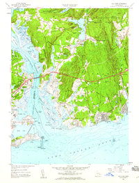
(5)- 1951 Map of Lyme
 1951 Lyme1951 Print · USGSThe Connecticut shoreline at the start of the fifties shows a transition from quiet rural hills to bustling beach colonies. Trace family roots and local history at the Duck River Cem, Lynde Pt Lighthouse, and the Lyme Sta railroad stop.2 unique versions available
 - 1952 Map of Hamburg, 1954 Print
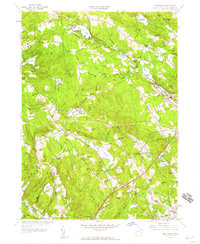
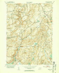 1952 Hamburg1954 Print · USGSIn the early 1950s, this pocket of New London County remained a landscape of dense state forests and scattered farmsteads. Researchers can trace numerous family burial sites like Millington Cem or explore the grounds of the Yale Engineering Camp and Devils Hopyard State Park.3 unique versions available
 - 1958 Map of Niantic, 1959 Print
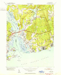
 1958 Niantic1959 Print · USGSThe Connecticut coast at the dawn of the interstate era shows a mix of summer colonies and institutional history. Trace the development of Niantic and East Lyme through landmarks like the State Military Camp, Millstone Quarry, and the New London Airport.3 unique versions available
 - 1958 Map of Old Lyme, 1959 Print
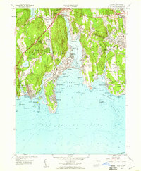
 1958 Old Lyme1959 Print · USGSThe Connecticut shoreline transitions into a new era of travel just as the turnpike is being established near Old Lyme. Genealogists and historians can trace family plots at Duck River Cem or locate the old Lyme Station along the rail line.6 unique versions available
 - 1958 Map of Montville, 1959 Print
 1958 Montville1959 Print · USGSMontville and East Lyme are captured during a period of steady mid-century growth along the Salem Turnpike and rural crossroads. Genealogists and historians can trace family-named landmarks and old burial sites like Whitaker Cem, Oakdale Fox Cem, and Chapel Hill.4 unique versions available
End of results
Showing maps 1-5 of 5
Top cities near East Lyme
- Norwich historical maps
- Groton historical maps
- East Hampton historical maps
- New London historical maps
- Southold historical maps
- Montville historical maps
See more
Top neighborhoods of East Lyme
- Crescent Park historical maps
- Flanders historical maps
- Pine Grove historical maps
- Giants Neck historical maps
- Old Black Point Association historical maps
- Saunders Point historical maps
See more
Frequently asked questions
- What are the different types of historical maps available for East Lyme?
- What is the oldest map of East Lyme?
- Where can I purchase historical maps of East Lyme for my home or office?
- Where can I download high-res historical maps of East Lyme?
- Are there historical topographic maps available for East Lyme?
- Is there historical aerial imagery available for East Lyme?
- Where are historical maps of East Lyme sourced from?