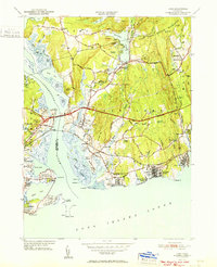
1951 Map of Lyme
USGS Topo · Published 1951About this map
The Connecticut River meets the Long Island Sound at this coastal crossroads, where the Raymond E Baldwin Bridge carries traffic over the water near Old Lyme. The landscape reflects a mix of maritime tradition and mid-century recreation, with beach communities like Sound View and Hawks Nest Beach lining the southern shore. Inland, the terrain is defined by low ridges such as Johnnycake Hill and water bodies including Rogers Lake and Black Hall Pond.
Find a feature on this map
101 named features on this map. Tap any name to fly to it.
Don’t see what you’re looking for? This feature index may not catch every label — zoom into the map to look around manually.
Map Details
Editions of this 1951 Lyme Map
2 editions found
Other maps of this area

1892 · New London
USGS Topo · 1:62,500

1893 · New London
USGS Topo · 1:62,500

1893 · Saybrook
USGS Topo · 1:62,500

1903 · Gardiners Island
USGS Topo · 1:62,500

1904 · Gardiners Island
USGS Topo · 1:62,500

1921 · Gardiners Island
USGS Topo · 1:62,500

1921 · New London
USGS Topo · 1:62,500

1934 · Niantic
USGS Topo · 1:24,000

1935 · Montville
USGS Topo · 1:24,000

1938 · Niantic
USGS Topo · 1:62,500