1980s Maps of East Lyme, Connecticut
Explore 3 historic maps of East Lyme from the 1980s. These maps offer a rare glimpse into what life looked like during the 1980s — showing old roads, neighborhoods, homes, and landmarks that have changed or disappeared over time.
Whether you're researching your family's past, planning a metal detecting trip, or studying how East Lyme's landscape evolved across the 1980s, these high-resolution maps are a powerful tool for exploring the history of this region.
- Focus on a specific era: All maps on this page are from the 1980s, giving you a focused view of this time period.
- See what’s changed: Compare century-old streets, trails, and buildings to today's modern landscape using overlays and satellite layers.
- Research with precision: Use these maps for genealogy, historical research, land use analysis, or educational projects.
- View, download, or print: Maps are fully viewable online in high resolution, and can be downloaded or printed for your own records.
Start exploring East Lyme's history through authentic maps from the 1980s. This is your window into the past.
East Lyme, CT maps
(3)- 1983 Map of Niantic
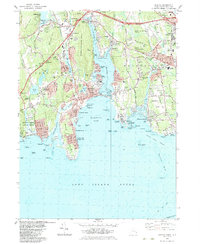 1983 Niantic1983 Print · USGSCoastal Connecticut in the early eighties shows a landscape of beach colonies and strategic infrastructure. Researchers can trace the development of Niantic and Flanders while locating local landmarks like Stone Church, Jordan Cem, and the New London-Waterford Airport.3 unique versions available
 - 1983 Map of Montville, 1984 Print
 1983 Montville1984 Print · USGSNew London County's interior is captured here in the early eighties, showcasing a mix of suburban growth and traditional water-driven industry. Genealogists can trace family names across Noble Hill or Haines Hill, and locate local landmarks like Macks Mill and the Oakdale Sch.
 - 1983 Map of New Haven, 1985 Print
 1983 New Haven1985 Print · USGSThe Connecticut shoreline and eastern Long Island are documented here in the early eighties, from the streets of New Haven to the piers of New London. Genealogists and historians can trace the geography of maritime heritage and academia at Yale University and the U.S. Coast Guard Academy.2 unique versions available
End of results
Showing maps 1-3 of 3
Top cities near East Lyme
- Norwich historical maps
- Groton historical maps
- East Hampton historical maps
- New London historical maps
- Southold historical maps
- Montville historical maps
See more
Top neighborhoods of East Lyme
- Crescent Park historical maps
- Flanders historical maps
- Pine Grove historical maps
- Giants Neck historical maps
- Old Black Point Association historical maps
- Saunders Point historical maps
See more
Frequently asked questions
- What are the different types of historical maps available for East Lyme?
- What is the oldest map of East Lyme?
- Where can I purchase historical maps of East Lyme for my home or office?
- Where can I download high-res historical maps of East Lyme?
- Are there historical topographic maps available for East Lyme?
- Is there historical aerial imagery available for East Lyme?
- Where are historical maps of East Lyme sourced from?