1980s Maps of Montville, Connecticut
Explore 6 historic maps of Montville from the 1980s. These maps offer a rare glimpse into what life looked like during the 1980s — showing old roads, neighborhoods, homes, and landmarks that have changed or disappeared over time.
Whether you're researching your family's past, planning a metal detecting trip, or studying how Montville's landscape evolved across the 1980s, these high-resolution maps are a powerful tool for exploring the history of this region.
- Focus on a specific era: All maps on this page are from the 1980s, giving you a focused view of this time period.
- See what’s changed: Compare century-old streets, trails, and buildings to today's modern landscape using overlays and satellite layers.
- Research with precision: Use these maps for genealogy, historical research, land use analysis, or educational projects.
- View, download, or print: Maps are fully viewable online in high resolution, and can be downloaded or printed for your own records.
Start exploring Montville's history through authentic maps from the 1980s. This is your window into the past.
Montville, CT maps
(6)- 1983 Map of Norwich
 1983 Norwich1983 Print · USGSThe industrial river valleys of New London County are shown here in the early 1980s as modern infrastructure met historic mill towns. Researchers can trace family sites at Long Society Cem, locate schools like Orchard Hill Sch, or study the rail corridors of Conrail.2 unique versions available
 - 1983 Map of Montville, 1984 Print
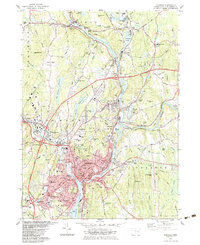
 1983 Montville1984 Print · USGSNew London County's interior is captured here in the early eighties, showcasing a mix of suburban growth and traditional water-driven industry. Genealogists can trace family names across Noble Hill or Haines Hill, and locate local landmarks like Macks Mill and the Oakdale Sch.
 - 1983 Map of Fitchville, 1984 Print
 1983 Fitchville1984 Print · USGSThe rural landscapes of Bozrah and Lebanon come alive in this early 1980s survey, showing a network of historic hill settlements and river valleys. Genealogists can trace family lines through New Lebanon Cem and Bozrah Cem or locate old industrial markers like the Central Vermont railroad.
 - 1983 Map of New Haven, 1985 Print
 1983 New Haven1985 Print · USGSThe Connecticut shoreline and eastern Long Island are documented here in the early eighties, from the streets of New Haven to the piers of New London. Genealogists and historians can trace the geography of maritime heritage and academia at Yale University and the U.S. Coast Guard Academy.2 unique versions available
 - 1984 Map of Uncasville
 1984 Uncasville1984 Print · USGSThe Thames River valley in the early 1980s was a hub of naval and academic activity, from the USCG Academy to the U S Naval Reservation. Genealogists and historians can trace the foundations of Gales Ferry, locate dozens of burial sites like Hebrew Cem, and find landmarks like the Norwich State Hospital.2 unique versions available
 - 1986 Map of Hartford
 1986 Hartford1986 Print · USGSCentral Connecticut and the surrounding highlands were undergoing significant suburban growth and industrial transition during the mid-eighties. Researchers can trace the layout of regional landmarks including Bradley International Airport, the University of Connecticut, and the historic State Capitol.
End of results
Showing maps 1-6 of 6
Top cities near Montville
- Norwich historical maps
- Groton historical maps
- New London historical maps
- Windham historical maps
- Southold historical maps
- Waterford historical maps
See more
Top neighborhoods of Montville
- Oakdale historical maps
- Palmertown historical maps
- Uncasville historical maps
- Kitemaug historical maps
- Massapeag historical maps
- Chesterfield historical maps
See more
Frequently asked questions
- What are the different types of historical maps available for Montville?
- What is the oldest map of Montville?
- Where can I purchase historical maps of Montville for my home or office?
- Where can I download high-res historical maps of Montville?
- Are there historical topographic maps available for Montville?
- Is there historical aerial imagery available for Montville?
- Where are historical maps of Montville sourced from?