1940s Maps of Preston, Connecticut
Explore 11 historic maps of Preston from the 1940s. These maps offer a rare glimpse into what life looked like during the 1940s — showing old roads, neighborhoods, homes, and landmarks that have changed or disappeared over time.
Whether you're researching your family's past, planning a metal detecting trip, or studying how Preston's landscape evolved across the 1940s, these high-resolution maps are a powerful tool for exploring the history of this region.
- Focus on a specific era: All maps on this page are from the 1940s, giving you a focused view of this time period.
- See what’s changed: Compare century-old streets, trails, and buildings to today's modern landscape using overlays and satellite layers.
- Research with precision: Use these maps for genealogy, historical research, land use analysis, or educational projects.
- View, download, or print: Maps are fully viewable online in high resolution, and can be downloaded or printed for your own records.
Start exploring Preston's history through authentic maps from the 1940s. This is your window into the past.
Preston, CT maps
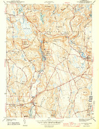
(11)- 1941 Map of Uncasville
 1941 Uncasville1941 Print · USGSThe Thames River corridor is captured here in the late 1930s, showing a vital mix of naval activity, collegiate rowing traditions, and old New England hamlets. Researchers can locate dozens of family cemeteries and landmarks like the Submarine Base, the Yale Boathouse, and The Ledyard Oak.2 unique versions available
 - 1942 Map of Block Island, 1943 Print
 1942 Block Island1943 Print · USGSThe coastal borderlands of Rhode Island and Connecticut are captured here during the wartime years, documenting a landscape defined by rail and sea. Researchers can trace the NY NH & H RR through historic mill villages or locate landmarks like the Silex Mine and Indian Burying Hill.2 unique versions available
 - 1943 Map of Old Mystic
 1943 Old Mystic1943 Print · USGSCoastal Connecticut’s rural interior is captured here during the early war years, showing the intersection of Ledyard, Groton, and North Stonington. Genealogists can locate family landmarks such as Haleys, Burnetts Corner, and the Pequot Indian Reservation.2 unique versions available
 - 1943 Map of Putnam, 1944 Print
 1943 Putnam1944 Print · USGSThe Connecticut and Rhode Island borderlands are captured here during the wartime era, showing a landscape defined by textile river towns and sprawling state forests. Trace the industrial rail corridor of the New York New Haven and Hartford through Putnam, Danielson, and Moosup.
 - 1944 Map of Jewett City
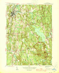 1944 Jewett City1944 Print · USGSGriswold and Voluntown appear during the mid-forties as a landscape of mill ponds, family-named hills, and developing state forest land. Researchers can trace the industrial corridor of the Hartford New Haven and New York RR or locate rural landmarks like Bethel Ch and Pachaug Cem.3 unique versions available
 - 1945 Map of Norwich
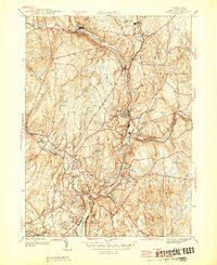 1945 Norwich1945 Print · USGSEastern Connecticut's industrial heart comes into focus during the mid-forties as the rail lines follow the winding river valleys. Genealogists can locate family sites near St Marys Cem, Elizabeth St Sch, and the old neighborhoods of Greenville.
 - 1946 Map of Norwich
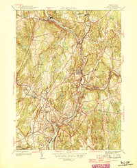 1946 Norwich1946 Print · USGSPost-war Norwich and its neighboring river towns sit at the heart of this industrial landscape during the mid-forties. Genealogists and historians can trace the growth of Taftville, the legacy of the Free Academy, and old burial sites like Yantic Cem.
 - 1947 Map of Providence, 1948 Print
 1947 Providence1948 Print · USGSSouthern New England is captured in the mid-1940s, showing a landscape defined by busy industrial ports and expanding military installations. Researchers can trace the rail lines of the N.Y. N.H. & H. RR or locate coastal defenses like Fort Adams and Quonset Point.5 unique versions available
 - 1947 Map of Hartford, 1955 Print
 1947 Hartford1955 Print · USGSSouthern New England and the Hudson Valley are shown in detail during the post-war expansion era. Genealogists and researchers can trace local landmarks from the State Capitol and Yale University to the Stratford Lighthouse and Woodlawn Cem.2 unique versions available
 - 1948 Map of Hartford
 1948 Hartford1948 Print · USGSSouthern New England is captured here in the late 1940s, showcasing a landscape of thriving industrial cities and developing parkways. Genealogists and historians can trace the rail networks of the New York New Haven and Hartford RR or locate coastal defense sites like Fort Terry and Camp Shanks.2 unique versions available
 - 1948 Map of Providence, 1951 Print
 1948 Providence1951 Print · USGSSouthern New England’s coastal reaches are captured here in the late 1940s, from the industrial heart of Providence to the tip of Provincetown. Genealogists and historians can trace rail lines like the Central Vermont Railway and locate active military sites such as Otis Air Force Base and Fort Rodman.
End of results
Showing maps 1-11 of 11
Top cities near Preston
- Norwich historical maps
- Groton historical maps
- Coventry historical maps
- New London historical maps
- Mansfield historical maps
- Windham historical maps
See more
Top neighborhoods of Preston
- Poquetanuck historical maps
- Hallville historical maps
- Happyland historical maps
- Preston City historical maps
- Shewville historical maps
- Hallville Mill Historic District historical maps
See more
Frequently asked questions
- What are the different types of historical maps available for Preston?
- What is the oldest map of Preston?
- Where can I purchase historical maps of Preston for my home or office?
- Where can I download high-res historical maps of Preston?
- Are there historical topographic maps available for Preston?
- Is there historical aerial imagery available for Preston?
- Where are historical maps of Preston sourced from?