1950s Maps of Felton, Delaware
Explore 6 historic maps of Felton from the 1950s. These maps offer a rare glimpse into what life looked like during the 1950s — showing old roads, neighborhoods, homes, and landmarks that have changed or disappeared over time.
Whether you're researching your family's past, planning a metal detecting trip, or studying how Felton's landscape evolved across the 1950s, these high-resolution maps are a powerful tool for exploring the history of this region.
- Focus on a specific era: All maps on this page are from the 1950s, giving you a focused view of this time period.
- See what’s changed: Compare century-old streets, trails, and buildings to today's modern landscape using overlays and satellite layers.
- Research with precision: Use these maps for genealogy, historical research, land use analysis, or educational projects.
- View, download, or print: Maps are fully viewable online in high resolution, and can be downloaded or printed for your own records.
Start exploring Felton's history through authentic maps from the 1950s. This is your window into the past.
Felton, DE maps
(6)- 1955 Map of Wilmington
 1955 Wilmington1955 Print · USGSThe Delaware Valley and Jersey Shore are seen here during the mid-fifties era of rapid suburban expansion and highway development. You can trace the path of the New Jersey Turnpike, locate the Fort Dix Military Reservation, or explore the rail networks of the Pennsylvania Railroad.
 - 1955 Map of Harrington, 1957 Print
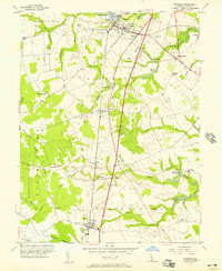
 1955 Harrington1957 Print · USGSHarrington and the surrounding Kent County farm country are shown in the mid-fifties at a peak of rail-driven activity. Genealogists and local historians can trace family locations near Reeves Crossing, Houston, and the rural St Mark Ch.3 unique versions available
 - 1956 Map of Wyoming, 1957 Print
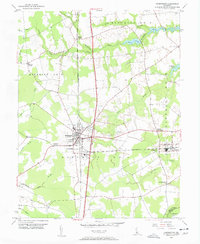
 1956 Wyoming1957 Print · USGSIn the mid-1950s, the rural landscape of central Delaware was characterized by a strong rail-and-water economy. Researchers can trace ancestral locations across Woodside, Viola, and Felton, or locate community landmarks like Voshell Mill and St Johns Ch.3 unique versions available
 - 1957 Map of Wilmington
 1957 Wilmington1957 Print · USGSThe mid-Atlantic coastal plain comes alive in the mid-fifties as the New Jersey Turnpike and Garden State Parkway redefine travel. Researchers can trace the rail-to-road transition and find landmarks like Ship John Shoal Light and the Fort Dix Military Reservation.2 unique versions available
 - 1957 Map of Salisbury
 1957 Salisbury1957 Print · USGSThe Delmarva Peninsula in the mid-1950s reveals a landscape of coastal defenses and rail-driven commerce. Researchers can trace the Pennsylvania railroad lines or locate historic landmarks like the Fenwick Island Lighthouse and St Martin church.
 - 1959 Map of Wilmington
 1959 Wilmington1959 Print · USGSThe Delaware Valley and Jersey Shore are seen here in the late fifties, during a period of massive suburban and highway expansion. Researchers can trace mid-century infrastructure like the N J Turnpike or locate coastal landmarks from Barnegat Bay to the Maurice River.3 unique versions available
End of results
Showing maps 1-6 of 6
Top cities near Felton
- Dover historical maps
- Milford historical maps
- Denton historical maps
- Highland Acres historical maps
- Harrington historical maps
- Dover Base historical maps
See more
Top neighborhoods of Felton
Frequently asked questions
- What are the different types of historical maps available for Felton?
- What is the oldest map of Felton?
- Where can I purchase historical maps of Felton for my home or office?
- Where can I download high-res historical maps of Felton?
- Are there historical topographic maps available for Felton?
- Is there historical aerial imagery available for Felton?
- Where are historical maps of Felton sourced from?