1950s Maps of New Castle County, Delaware
Explore 22 historic maps of New Castle County from the 1950s. These maps offer a rare glimpse into what life looked like during the 1950s — showing old roads, neighborhoods, homes, and landmarks that have changed or disappeared over time.
Whether you're researching your family's past, planning a metal detecting trip, or studying how New Castle County's landscape evolved across the 1950s, these high-resolution maps are a powerful tool for exploring the history of this region.
- Focus on a specific era: All maps on this page are from the 1950s, giving you a focused view of this time period.
- See what’s changed: Compare century-old streets, trails, and buildings to today's modern landscape using overlays and satellite layers.
- Research with precision: Use these maps for genealogy, historical research, land use analysis, or educational projects.
- View, download, or print: Maps are fully viewable online in high resolution, and can be downloaded or printed for your own records.
Start exploring New Castle County's history through authentic maps from the 1950s. This is your window into the past.
New Castle County, DE maps
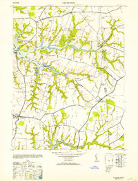
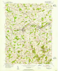
(22)- 1950 Map of Taylors Bridge
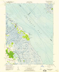
 1950 Taylors Bridge1950 Print · USGSThe Delaware riverfront of New Castle County appears here as a complex network of marshes and landings in the late 1940s. Genealogists can trace early homesteads and landmarks like Taylors Bridge, Thomas Landing, and Vance Neck.
 - 1951 Map of Delaware City
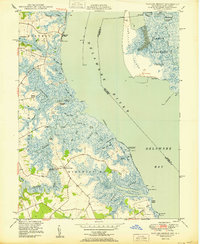
 1951 Delaware City1951 Print · USGSCoastal Delaware and New Jersey meet along the tidal river and canal in the early fifties, before modern expansion altered the marshlands. Genealogists and historians can locate Finns Point National Cemetery, the river defenses of Fort Delaware, and old schoolhouses like Union Sch.
 - 1951 Map of Cecilton
 1951 Cecilton1951 Print · USGSThe upper Eastern Shore at mid-century reveals a landscape defined by deep river necks and quiet crossroads. Genealogists can locate family landmarks such as Bohemia Manor, Shrewsbury Ch, and small settlements like Earleville or Galena.2 unique versions available
 - 1951 Map of Penns Grove
 1951 Penns Grove1951 Print · USGSCoastal Salem County is seen here in the early fifties, showing a bustling riverfront economy and deep-rooted rural interior. Trace the Reading Seashore Lines to Friendship Sta or locate family sites near Haines Neck Ch and Biddles Landing.2 unique versions available
 - 1953 Map of Cecilton
 1953 Cecilton1953 Print · USGSThe Cecil County shoreline and the Maryland-Delaware border are captured here in the mid-1940s. Genealogists and local historians can trace the estates and rural hubs of Cecilton, locate Bohemia Manor Church, and find markers like MD-DEL Boundary Mon 5.2 unique versions available
 - 1953 Map of Elkton, 1954 Print
 1953 Elkton1954 Print · USGSMid-century Cecil County is defined by the vital shipping corridors and rail lines connecting the Chesapeake and Delaware bays. Genealogists and historians can trace family-named sites like Gilpin Cem, rural landmarks such as Jones Chapel, and the industrial wharf at Old Frenchtown Wharf.4 unique versions available
 - 1953 Map of Saint Georges, 1954 Print
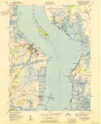
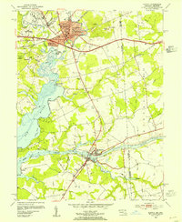
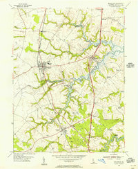
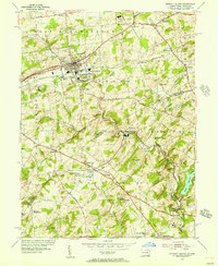
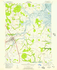
 1953 Saint Georges1954 Print · USGSMid-century New Castle County is defined here by the engineering of the Chesapeake and Delaware Canal and the primary transit corridor of the Dupont Parkway. Genealogists and local historians can trace the foundations of Saint Georges, identify family burial sites at Hickory Grove Cem, and locate former institutions like Kings College.5 unique versions available
 - 1953 Map of Newark West, 1954 Print
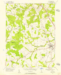
 1953 Newark West1954 Print · USGSThe tristate borderlands of Maryland, Pennsylvania, and Delaware appear here in the early fifties as the University of Delaware and Newark began their modern expansion. Local historians can trace the Mason and Dixon Line across the landscape, past historic sites like Welsh Tract Ch Cem and Elk Mills.6 unique versions available
 - 1953 Map of West Grove, 1955 Print
 1953 West Grove1955 Print · USGSSouthern Chester County thrived as a rail and agricultural hub in the early fifties, where the Pennsylvania railroad linked growing boroughs. Researchers can trace historic local institutions like the New London Academy, St Marys Cem, and the rural Maple Grove Sch.5 unique versions available
 - 1953 Map of Newark East, 1955 Print
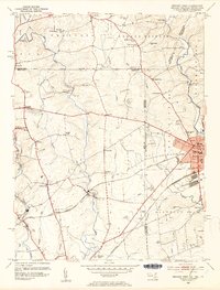
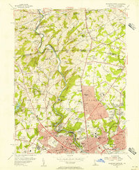
 1953 Newark East1955 Print · USGSMid-century New Castle County shows a landscape of burgeoning suburbs and deep-rooted industrial corridors. Researchers can locate family landmarks at Coochs Bridge, St James Ch, and the Delaware Park Race Track.4 unique versions available
 - 1953 Map of Millington, 1955 Print
 1953 Millington1955 Print · USGSThe Maryland and Delaware borderlands are captured here in the early 1950s, showing a landscape defined by river landings and rail junctions. Researchers can locate family landmarks at Peacock Corners and Coldwell Corners, or trace the old paths between Golts, Massey, and Millington.3 unique versions available
 - 1953 Map of Middletown, 1956 Print
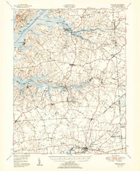
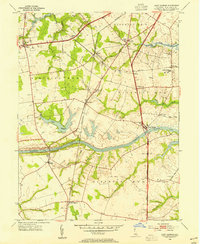
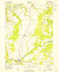
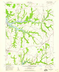
 1953 Middletown1956 Print · USGSNew Castle County at mid-century remains an agricultural and rail-connected landscape as the modern parkway system begins to take shape. Genealogists and historians can trace local families through landmarks like Wiggins Mill, Blackbird Landing, and rural churches such as Union Ch.2 unique versions available
 - 1953 Map of Marcus Hook, 1956 Print
 1953 Marcus Hook1956 Print · USGSThe industrial waterfront of the Delaware River comes alive in the early fifties, from the refineries of Marcus Hook to the busy streets of Chester. Trace family roots at Mt Hope Ch Cem or locate vanished landmarks like the U S Quarantine Sta and Tank Farm.2 unique versions available
 - 1954 Map of Kennett Square, 1956 Print
 1954 Kennett Square1956 Print · USGSThe Pennsylvania and Delaware borderlands are shown here in the mid-fifties as the region balanced its rural roots with industrial growth. Genealogists and historians can trace family locations through sites like Old Kennett Meetinghouse, Hockessin, and Yorklyn.6 unique versions available
 - 1954 Map of Wilmington North, 1956 Print
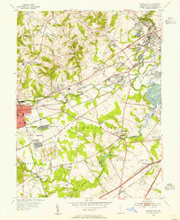
 1954 Wilmington North1956 Print · USGSNorthern Delaware and the Pennsylvania borderlands appear here in the mid-fifties, dominated by the legendary estates and facilities of the Du Pont family. Genealogists and local historians can trace the development of Fairfax and Centerville or locate landmarks like Guyencourt and the Alfred I Du Pont Institute.2 unique versions available
 - 1955 Map of Wilmington
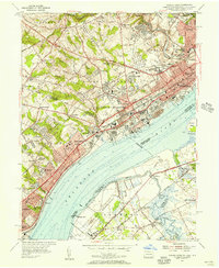
 1955 Wilmington1955 Print · USGSThe Delaware Valley and Jersey Shore are seen here during the mid-fifties era of rapid suburban expansion and highway development. You can trace the path of the New Jersey Turnpike, locate the Fort Dix Military Reservation, or explore the rail networks of the Pennsylvania Railroad.
 - 1955 Map of Clayton, 1956 Print
 1955 Clayton1956 Print · USGSUpper Delaware in the mid-fifties shows a landscape of rail-connected towns and historic crossroads on the New Castle and Kent County line. Genealogists and local historians can trace family-named hubs like Grears Corners, Thomas Corners, and institutions like the St Joseph Industrial Sch.3 unique versions available
 - 1956 Map of Bombay Hook
 1956 Bombay Hook1956 Print · USGSThe Delaware coast in the mid-1950s is defined by the wetlands of the Bombay Hook National Wildlife Refuge. Researchers can trace old family lands and waterways like Whitehall Neck, Woodland Beach, and Dutch Neck Canal.4 unique versions available
 - 1956 Map of Smyrna, 1957 Print
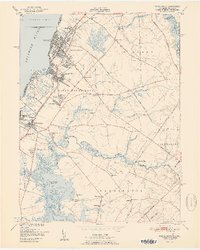
 1956 Smyrna1957 Print · USGSThe town of Smyrna and its surrounding rural districts are shown in the mid-fifties as the local economy balanced rail transport with coastal marsh management. Researchers can trace family-named sites like Belmont Hall or locate rural landmarks such as Friendship Ch and Dutch Neck Crossroads.3 unique versions available
 - 1957 Map of Wilmington
 1957 Wilmington1957 Print · USGSThe mid-Atlantic coastal plain comes alive in the mid-fifties as the New Jersey Turnpike and Garden State Parkway redefine travel. Researchers can trace the rail-to-road transition and find landmarks like Ship John Shoal Light and the Fort Dix Military Reservation.2 unique versions available
 - 1958 Map of Cecilton, 1959 Print
 1958 Cecilton1959 Print · USGSSouthern Cecil County and the Maryland-Delaware border are captured here in the late fifties, showcasing a rural landscape defined by the Bohemia River. Researchers can trace old family settlements and parish roots at St Francis Xavier Ch, Warwick, and Bohemia Mills.3 unique versions available
 - 1959 Map of Wilmington
 1959 Wilmington1959 Print · USGSThe Delaware Valley and Jersey Shore are seen here in the late fifties, during a period of massive suburban and highway expansion. Researchers can trace mid-century infrastructure like the N J Turnpike or locate coastal landmarks from Barnegat Bay to the Maurice River.3 unique versions available
End of results
Showing maps 1-22 of 22
Top cities of New Castle County
- Wilmington historical maps
- Newark historical maps
- Hockessin historical maps
- Middletown historical maps
- Claymont historical maps
- Wilmington Manor historical maps
See more
Frequently asked questions
- What are the different types of historical maps available for New Castle County?
- What is the oldest map of New Castle County?
- Where can I purchase historical maps of New Castle County for my home or office?
- Where can I download high-res historical maps of New Castle County?
- Are there historical topographic maps available for New Castle County?
- Is there historical aerial imagery available for New Castle County?
- Where are historical maps of New Castle County sourced from?