1990s Maps of New Castle County, Delaware
Explore 26 historic maps of New Castle County from the 1990s. These maps offer a rare glimpse into what life looked like during the 1990s — showing old roads, neighborhoods, homes, and landmarks that have changed or disappeared over time.
Whether you're researching your family's past, planning a metal detecting trip, or studying how New Castle County's landscape evolved across the 1990s, these high-resolution maps are a powerful tool for exploring the history of this region.
- Focus on a specific era: All maps on this page are from the 1990s, giving you a focused view of this time period.
- See what’s changed: Compare century-old streets, trails, and buildings to today's modern landscape using overlays and satellite layers.
- Research with precision: Use these maps for genealogy, historical research, land use analysis, or educational projects.
- View, download, or print: Maps are fully viewable online in high resolution, and can be downloaded or printed for your own records.
Start exploring New Castle County's history through authentic maps from the 1990s. This is your window into the past.
New Castle County, DE maps
(26)- 1992 Map of Newark West, 1993 Print
 1992 Newark West1993 Print · USGSThe borderlands of Maryland, Delaware, and Pennsylvania are shown in the early nineties, centered on the equestrian landscapes of Fair Hill. Trace family roots at the Welsh Tract Ch or locate the Fair Hill Training Center and Elk Mills.3 unique versions available
 - 1992 Map of Elkton, 1993 Print
 1992 Elkton1993 Print · USGSMaryland and Delaware meet along this corridor in the early nineties as suburban expansion reaches the historic Cecil County seat. Genealogists can trace family names and sites from Gilpin Cem and Crouch Chapel to the industrial legacy of the Chesapeake and Delaware Canal.
 - 1993 Map of Canton
 1993 Canton1993 Print · USGSCoastal Salem County comes into focus in the early nineties, showing a landscape defined by the vast marshlands of the Delaware Bay. Researchers can trace historic crossroads and tide-water landmarks from Harmersville down to Stow Creek Landing and the old milling site at Maskells Mill.
 - 1993 Map of Cecilton
 1993 Cecilton1993 Print · USGSThe Maryland-Delaware borderlands near the Sassafras River come into focus in the early nineties, showing a landscape defined by tidal creeks and historic necks. Genealogists and local researchers can trace sites like St Francis Xavier Ch, Bohemia Mills, and the small settlement at Cayots.
 - 1993 Map of Taylors Bridge
 1993 Taylors Bridge1993 Print · USGSThe Delaware shoreline and tidal marshes are captured in the early 1990s as the Salem Nuclear Powerplant stands opposite historic rural landings. Researchers can trace local genealogy and land use through Taylors Bridge, old schools along Walker School Road, and the family-named Thomas Landing.
 - 1993 Map of Newark East
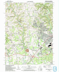
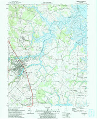
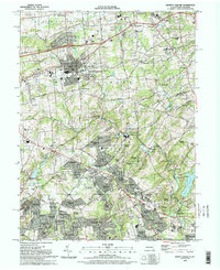
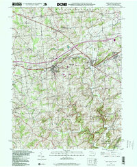
 1993 Newark East1993 Print · USGSNewark and the surrounding Delaware suburbs are captured here in the early nineties as modern residential life integrates with historic transport corridors. Researchers can locate community anchors like Delaware Park, All Saints Cemetery, and Goldey Beacom College.2 unique versions available
 - 1993 Map of Marcus Hook
 1993 Marcus Hook1993 Print · USGSThe Delaware River shoreline at Marcus Hook and Chester is captured here in the early nineties during its peak industrial era. Researchers can trace neighborhood growth near Archmere Academy and locate family landmarks like Immaculate Heart Ch & Cem.2 unique versions available
 - 1993 Map of Saint Georges
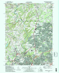
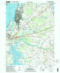
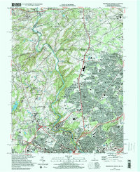
 1993 Saint Georges1993 Print · USGSNew Castle County in the early nineties shows the widening contrast between its maritime industrial corridors and expanding residential suburbs. Researchers can trace historic family landmarks and rural infrastructure from Summit Bridge to the quiet Hickory Grove Cemetery and Saint Georges.
 - 1993 Map of Smyrna
 1993 Smyrna1993 Print · USGSSmyrna and the surrounding Delaware wetlands are captured here in the early nineties as suburban expansion began meeting the coastal marshlands. Genealogists and local historians can locate Friendship Ch, trace the banks of Duck Creek, and explore old landings like Smyrna Landing.
 - 1993 Map of Bombay Hook Island
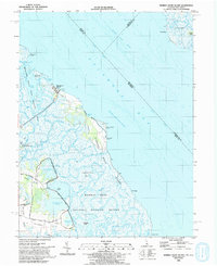 1993 Bombay Hook Island1993 Print · USGSThe Delaware Bay shoreline in the early 1990s is defined by vast coastal wetlands and managed wildlife habitats. Trace the land use patterns near Woodland Beach and the family-named roads leading to Whitehall and Whitehall Landing.
 - 1993 Map of Millington
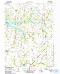
 1993 Millington1993 Print · USGSThe Upper Eastern Shore at the start of the nineties reveals a landscape of river landings and wooded management areas. Trace the quiet crossroads of Massey and Golts or locate family sites at St Clements Ch and Shorewood.
 - 1993 Map of Penns Grove
 1993 Penns Grove1993 Print · USGSThe Delaware River shoreline at Penns Grove and Carneys Point is captured here in the early nineties. Genealogists can locate family landmarks like Bethel Ch and Marshalltown or trace the Wilmington & Northern Branch rail line.
 - 1993 Map of Kennett Square
 1993 Kennett Square1993 Print · USGSThe Pennsylvania and Delaware borderlands are documented here in the early nineties, centered on the borough of Kennett Square. Genealogists and local historians can trace legacy sites like the Old Kennett Meeting House, Longwood Cem, and the Covered Bridge near Ashland.
 - 1993 Map of Wilmington North
 1993 Wilmington North1993 Print · USGSThe Brandywine Valley at the start of the 1990s reveals a sophisticated mix of colonial heritage and modern corporate-industrial campuses. Genealogists and historians can trace established neighborhoods like Westover Hills and landmarks such as the Quaker Meeting House or Hagley Museum.2 unique versions available
 - 1993 Map of Clayton
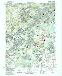
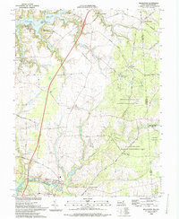
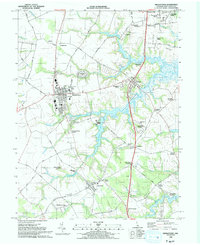
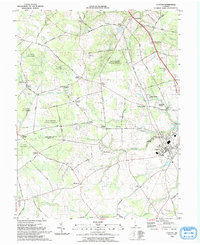 1993 Clayton1993 Print · USGSThe rural borderlands of New Castle and Kent Counties are captured here in the early nineties, centered on the wooded tracts of Blackbird State Forest. Researchers can trace old family locations near Blackiston, Clayton, and Reynolds Corners School.
 - 1993 Map of Delaware City
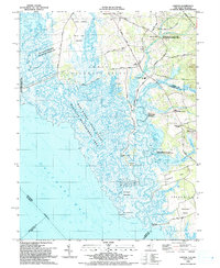
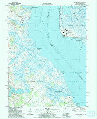
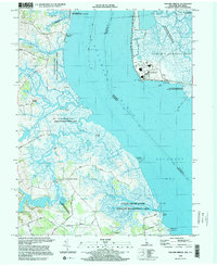
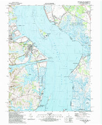 1993 Delaware City1993 Print · USGSThe Delaware riverfront and its coastal defenses appear in detail during the early nineties, showing the historic corridor between Delaware and New Jersey. Genealogists and historians can trace riverside settlements like Port Penn, the site of Fort Elfsborg, and the Finns Point National Cemetery.
 - 1993 Map of Wilmington South
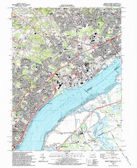
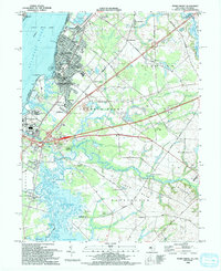
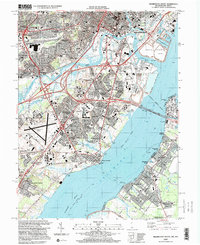
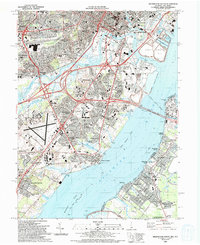 1993 Wilmington South1993 Print · USGSThe Delaware riverfront at Wilmington and New Castle is shown in the early nineties as a bustling network of ports, rail lines, and suburban growth. Genealogists and local researchers can trace legacy neighborhoods like Dobbinsville, identify historic sites such as Glebe Cem, and locate long-standing institutions like Conrad High Sch.
 - 1993 Map of Middletown
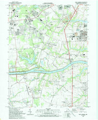
 1993 Middletown1993 Print · USGSMiddletown and Townsend are shown in the early nineties as established Delaware communities surrounded by family-named crossroads and historic river landings. Genealogists can trace family names at Old Drawyers Cem, Forest Cem, and the riverside Blackbird Landing.
 - 1995 Map of Penns Grove, 1999 Print
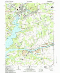
 1995 Penns Grove1999 Print · USGSThe riverfront and rail corridors of Salem County are captured here in the mid-1990s, showcasing the transition from industrial Penns Grove to tidal marshlands. Genealogists and local historians can trace family sites at Perkintown Cem, Marshalltown, and Biddles Landing.
 - 1995 Map of Marcus Hook, 2000 Print
 1995 Marcus Hook2000 Print · USGSThe industrial corridor and riverside towns of the tri-state border area appear in high detail during the late twentieth century. Genealogists and local historians can trace family roots through numerous sites like Greenlawn Cem, Archmere Academy, and the historic waterfront at Grubbs Landing.
 - 1997 Map of West Grove, 1999 Print
 1997 West Grove1999 Print · USGSChester County's rural character is well-preserved in the late nineties, anchored by the crossroads at West Grove and Avondale. Researchers can locate historic rural sites like New London Academy, the Penn Central line, and the St Francis Xavier Ch.
 - 1997 Map of Wilmington North, 2000 Print
 1997 Wilmington North2000 Print · USGSThe Brandywine Valley at the end of the century shows a sophisticated landscape of historic estates and educational institutions. Researchers can trace the boundaries of Brandywine Battlefield State Park or locate family sites near Silverbrook Cemetery and Chadds Ford.
 - 1997 Map of Wilmington South, 2000 Print
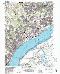
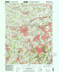
 1997 Wilmington South2000 Print · USGSThe industrial waterfront and growing suburbs south of Wilmington are captured here in the late 1990s as the region's transport network matured. Researchers can trace local landmarks from St Elizabeths Ch and Silverbrook Cem to the busy New Castle County Airport.
 - 1999 Map of West Grove, 2001 Print
 1999 West Grove2001 Print · USGSChester County at the turn of the millennium shows a landscape of established villages and interconnected creek branches. Genealogists and researchers can trace local landmarks from West Grove to Landenberg, including the New London Academy and St Marys Cem.
 - 1999 Map of Taylors Bridge, 2001 Print
 1999 Taylors Bridge2001 Print · USGSThe Delaware riverfront at the close of the century shows a unique mix of heavy industry and coastal preservation. Genealogists and researchers can trace family-named sites like Taylors Bridge, Thomas Landing, and Fennimore Landing alongside the Salem Nuclear Powerplant.
Showing maps 1-25 of 26
Top cities of New Castle County
- Wilmington historical maps
- Newark historical maps
- Hockessin historical maps
- Middletown historical maps
- Claymont historical maps
- Wilmington Manor historical maps
See more
Frequently asked questions
- What are the different types of historical maps available for New Castle County?
- What is the oldest map of New Castle County?
- Where can I purchase historical maps of New Castle County for my home or office?
- Where can I download high-res historical maps of New Castle County?
- Are there historical topographic maps available for New Castle County?
- Is there historical aerial imagery available for New Castle County?
- Where are historical maps of New Castle County sourced from?