1970s Maps of Bay County, Florida
Explore 2 historic maps of Bay County from the 1970s. These maps offer a rare glimpse into what life looked like during the 1970s — showing old roads, neighborhoods, homes, and landmarks that have changed or disappeared over time.
Whether you're researching your family's past, planning a metal detecting trip, or studying how Bay County's landscape evolved across the 1970s, these high-resolution maps are a powerful tool for exploring the history of this region.
- Focus on a specific era: All maps on this page are from the 1970s, giving you a focused view of this time period.
- See what’s changed: Compare century-old streets, trails, and buildings to today's modern landscape using overlays and satellite layers.
- Research with precision: Use these maps for genealogy, historical research, land use analysis, or educational projects.
- View, download, or print: Maps are fully viewable online in high resolution, and can be downloaded or printed for your own records.
Start exploring Bay County's history through authentic maps from the 1970s. This is your window into the past.
Bay County, FL maps
(2)- 1978 Map of Port Saint Joe, 1980 Print
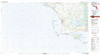 1978 Port Saint Joe1980 Print · USGSThe Florida Panhandle coastline in the late seventies reveals a landscape of massive wildlife refuges and critical maritime waterways. Genealogists and historians can trace the Apalachicola Northern rail line and locate coastal landmarks like Port St Joe and Beacon Hill.2 unique versions available
 - 1979 Map of Marianna, 1980 Print
 1979 Marianna1980 Print · USGSFlorida's northern panhandle and the neighboring Alabama-Georgia borderlands are captured here in the late seventies. Genealogists and local historians can trace family roots through settlements like Graceville and Cottondale or follow the historic Louisville and Nashville rail lines.2 unique versions available
End of results
Showing maps 1-2 of 2
Top cities of Bay County
- Panama City historical maps
- Upper Grand Lagoon historical maps
- Lynn Haven historical maps
- Callaway historical maps
- Panama City Beach historical maps
- Springfield historical maps
See more
Frequently asked questions
- What are the different types of historical maps available for Bay County?
- What is the oldest map of Bay County?
- Where can I purchase historical maps of Bay County for my home or office?
- Where can I download high-res historical maps of Bay County?
- Are there historical topographic maps available for Bay County?
- Is there historical aerial imagery available for Bay County?
- Where are historical maps of Bay County sourced from?