Old Maps of Bay County, Florida
Explore 190 old maps of Bay County, spanning from 1943 to today. These high-resolution historic maps reveal how streets, neighborhoods, landmarks, and natural features evolved over time — perfect for genealogy, metal detecting, research, and local history exploration.
What you can do with these maps:
- See how Bay County changed over time: Compare historical maps to modern-day views to trace roads, homesites, rail lines & more.
- View detailed metadata: Each map includes creators, publishers, year, scale, and archive source.
- Overlay maps with satellite & LiDAR: Visualize the past alongside modern tools to explore terrain & human change.
- Trusted historical sources: Maps sourced from the USGS, Library of Congress, and other archives.
- Access maps your way: View online, download high-res files, or order prints for personal or research use.
Start exploring old maps of Bay County to uncover forgotten places, hidden landmarks, and the deep history beneath your feet.
Bay County, FL maps
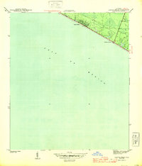
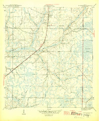
(190)- 1943 Map of Beacon Beach
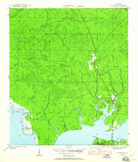
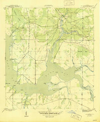
 1943 Beacon Beach1943 Print · USGSCoastal Florida in the early nineteen-forties reveals a landscape of isolated bayous and quiet shorelines before the postwar boom. Genealogists and local historians can trace the early layout of Beacon Beach and locate the Marywood Cem near Pearl Bayou.3 unique versions available
 - 1943 Map of Laguna Beach
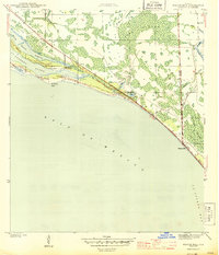
 1943 Laguna Beach1943 Print · USGSThe Florida Panhandle coast appears at the height of the war years, showing a sparsely settled shoreline along the Gulf of Mexico. Local historians can trace the early residential grids and coastal roads of Laguna Beach and Gulf Resort Beach before the post-war development boom.5 unique versions available
 - 1943 Map of Panama City
 1943 Panama City1943 Print · USGSPanama City and its waterfront neighborhoods are captured here during the wartime mobilization of the early 1940s. Genealogists and local historians can trace the development of Millville, Lynn Haven, and Panama City, along with landmarks like Greenwood Cem and the Municipal Pier.3 unique versions available
 - 1943 Map of Crooked Island
 1943 Crooked Island1943 Print · USGSThe Florida panhandle shoreline in the early 1940s reveals a wild, undeveloped coastal landscape shaped by the sea. Historians and coastal researchers can trace the natural barrier formations of Crooked Island and the tidal reaches of St Andrew Sound before modern development.3 unique versions available
 - 1943 Map of Panama City Beach
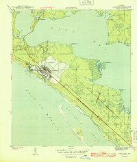
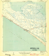 1943 Panama City Beach1943 Print · USGSPanama City Beach and the surrounding Florida coast are shown during the early 1940s before the era of high-rise development. Researchers can trace the original footprints of Betty Lou Beach and Florida Beach or follow the shoreline of Grand Lagoon.3 unique versions available
 - 1943 Map of Seminole Hills, 1969 Print
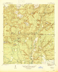
 1943 Seminole Hills1969 Print · USGSCoastal Bay County was a landscape of intricate wetlands and new shoreline settlements during the early 1940s. Genealogists and historians can trace the early footprints of Sunnyside and Laird or locate landmarks like County Line Landing and Powell Lake.
 - 1943 Map of West Bay, 1969 Print
 1943 West Bay1969 Print · USGSCoastal Florida in the early 1940s is defined by its winding waterways and undeveloped shoreline. Historians can trace early navigation along the Intracoastal Waterway and locate natural landmarks like Walsonham Point and Burnt Mill Creek.
 - 1943 Map of Southport, 1973 Print
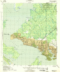
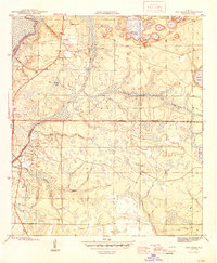
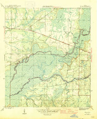
 1943 Southport1973 Print · USGSCoastal Bay County during the mid-forties reveals a landscape of tidal inlets and early bridge crossings before the modern expansion of Panama City. Genealogists and local researchers can trace early settlements at Southport and Vicksburg, or locate landmarks like the Vicksburg Fire Tower and North Bay Bridge.
 - 1944 Map of Beacon Hill
 1944 Beacon Hill1944 Print · USGSThe Florida Panhandle coastline and the edge of St. Joseph Bay appear here in the mid-1940s, documenting a landscape of small coastal settlements and tidal marsh. Researchers can trace early development at Beacon Hill and Davis Beach, or locate family-named landmarks like Joe Lamb Branch and Preacher Bryant Ponds.3 unique versions available
 - 1944 Map of Southport
 1944 Southport1944 Print · USGSThe shores of North Bay and West Bay are captured here during the mid-1940s, showing a landscape defined by tidal bayous and early coastal settlements. Local historians can trace the road networks connecting Southport, Vicksburg, and the early layout of Lynn Haven.5 unique versions available
 - 1944 Map of Seminole Hills
 1944 Seminole Hills1944 Print · USGSThe Florida Panhandle shoreline and interior wetlands are shown during the mid-forties, just as coastal communities were establishing themselves. Researchers can trace the early layout of Hollywood Beach and Sunnyside or locate old crossings at County Line Landing.4 unique versions available
 - 1944 Map of West Bay
 1944 West Bay1944 Print · USGSThe coastal village of West Bay and the surrounding Florida panhandle wetlands are captured in the mid-1940s. Trace the path of the Intracoastal Waterway and the winding reaches of Burnt Mill Creek and Crooked Creek.4 unique versions available
 - 1944 Map of Long Point
 1944 Long Point1944 Print · USGSThe Florida Panhandle coast during the Second World War was a landscape defined by rapid military expansion. Researchers can trace the early layout of Tyndall Field and explore the shoreline of St Andrew Sound and the settlement at San Blas.3 unique versions available
 - 1944 Map of Crystal Lake, 1964 Print
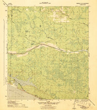
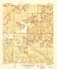
 1944 Crystal Lake1964 Print · USGSIn the Florida panhandle during the mid-1940s, this area showcases a landscape of countless named ponds and lakes along the Washington Co Bay Co line. Trace the routes of the C C C Road and locate family-named features like Tyson Lake and Brit Lake.
 - 1944 Map of Bayhead, 1967 Print
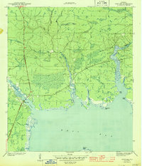
 1944 Bayhead1967 Print · USGSBay County's coastal lowlands and winding bayous are shown here during the mid-1940s, just as these waterfront communities were beginning to develop. Genealogists and historians can trace rail-and-water connections at Bayou George or locate early landings such as Mcallaster Landing.
 - 1944 Map of Bruce, 1969 Print
 1944 Bruce1969 Print · USGSThe Choctawhatchee River bottomlands in the 1940s reveal a landscape of remote river camps and timber landings. Trace the early footprints of Bruce and Ebro, and locate riverfront sites like Cedar Tree Landing and the Ebro Sch.
 - 1944 Map of Bennett, 1969 Print
 1944 Bennett1969 Print · USGSBay and Washington County during the mid-forties reveal a landscape of interconnected ponds and creek branches. Genealogists and local historians can trace family ties at Gainer Cem and Porter Cem or locate the rural settlement of Bennett.
 - 1945 Map of Youngstown
 1945 Youngstown1945 Print · USGSThe Florida Panhandle in the mid-forties reveals a landscape shaped by timber, rail, and water. Genealogists and local historians can trace the rail-side communities of Youngstown, Nixon, and Cairo, and locate the historic Bear Creek Ch.3 unique versions available
 - 1945 Map of Bennett
 1945 Bennett1945 Print · USGSUpper Bay County and southern Washington County are shown here in the mid-1940s, centered on the complex drainage of the Econfina Creek valley. Genealogists can locate the Gainer Cem and trace old industrial sites like Mitchell Mill Creek near Bennett.3 unique versions available
 - 1945 Map of Red Head
 1945 Red Head1945 Print · USGSThe Choctawhatchee River lowlands and the southern pine forests come into focus during the mid-1940s. Genealogists and local historians can locate early community hubs like Red Head and the Oak Grove Ch, or trace landmarks like the Moody Fire Tower and Ebro Cem.4 unique versions available
 - 1945 Map of Bayhead
 1945 Bayhead1945 Print · USGSThe northern reaches of St Andrews Bay come to life in this mid-1940s survey of coastal Florida. Genealogists and researchers can trace the early layout of Bayou George, the stops along the St Andrews and Atlanta RR, and landings like Mc Allaster Landing.3 unique versions available
 - 1945 Map of Allanton
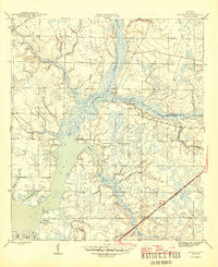
 1945 Allanton1945 Print · USGSCoastal Florida near the end of the Second World War was a landscape of intricate bayous and small fishing settlements. You can trace the early footprints of Allanton and Farmdale along the shores of East Bay and the Wetappo Intracoastal Waterway Creek.3 unique versions available
 - 1945 Map of North Of Allanton
 1945 North Of Allanton1945 Print · USGSBay County's dense swamp and bayou country is recorded here in the mid-1940s, showing a landscape defined by timber and tide. Researchers can locate the Kent Cem and trace the early route of Allanton Road past the Majette Fire Tower.3 unique versions available
 - 1945 Map of Bruce
 1945 Bruce1945 Print · USGSFlorida's Panhandle river country is captured here in the mid-1940s, showing the complex wetlands where Walton and Washington Counties meet. Researchers can trace the riverfront economy through sites like Cowford Ferry, Miller Landing, and the Ebro school.3 unique versions available
 - 1945 Map of Crystal Lake
 1945 Crystal Lake1945 Print · USGSThe Florida Panhandle on the border of Washington and Bay counties is captured here in the mid-1940s, showcasing a unique landscape of sinkhole lakes and backwoods trails. Researchers can trace early routes like the C C C Road and locate family-named features such as Tyson Lake, Brit Lake, and Crystal Lake.3 unique versions available
Showing maps 1-25 of 190
Top cities of Bay County
- Panama City historical maps
- Upper Grand Lagoon historical maps
- Lynn Haven historical maps
- Callaway historical maps
- Panama City Beach historical maps
- Springfield historical maps
See more
Frequently asked questions
- What are the different types of historical maps available for Bay County?
- What is the oldest map of Bay County?
- Where can I purchase historical maps of Bay County for my home or office?
- Where can I download high-res historical maps of Bay County?
- Are there historical topographic maps available for Bay County?
- Is there historical aerial imagery available for Bay County?
- Where are historical maps of Bay County sourced from?