
1945 Map of Bennett
USGS Topo · Published 1945About this map
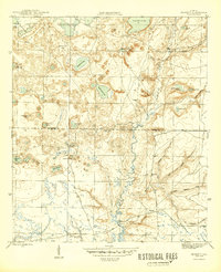
Econfina Creek carves a winding path through the center of this landscape, its steep banks and surrounding wetlands defining the topography of northern Florida just after World War II. The settlement at Bennett serves as a primary reference point in the south, while the northern reaches are dominated by the extensive Deadening Lakes system and Porter Lake. The terrain is characterized by numerous isolated water bodies and sinkholes, many with distinctive names like Rattlesnake Lake and Sparkleberry Pond, which imply the natural flora and fauna encountered by locals. For those researching family history or early land use, the Gainer Cem and the naming of Mitchell Mill Creek and Old Mill Branch provide evidence of early industry and community burial grounds along the Washington Co Bay Co line.
Find a feature on this map
32 named features on this map. Tap any name to fly to it.
Don’t see what you’re looking for? This feature index may not catch every label — zoom into the map to look around manually.
Map Details
Editions of this 1945 Bennett Map
3 editions found
Other maps of this area

1943 · Southport
USGS Topo · 1:24,000

1944 · Southport
USGS Topo · 1:24,000

1944 · Crystal Lake
USGS Topo · 1:24,000

1944 · Bayhead
USGS Topo · 1:24,000

1944 · Bennett
USGS Topo · 1:24,000

1945 · Youngstown
USGS Topo · 1:31,680

1945 · Bayhead
USGS Topo · 1:31,680

1945 · Crystal Lake
USGS Topo · 1:31,680

1945 · Fountain
USGS Topo · 1:31,680

1950 · Vernon
USGS Topo · 1:24,000