Old Maps of Bayhead, Florida for Metal Detecting
Plan your next treasure hunt with 9 historic maps of Bayhead. Find old homesites, ghost towns, trails, and gathering spots that may be lost to time — perfect for identifying promising metal detecting locations.
- Locate forgotten sites: Uncover places like long-lost settlements, abandoned rail lines, or gathering spots.
- Plan better hunts: Use map overlays combined with LiDAR or satellite views to narrow in on historically rich areas.
- Made for detectorists: Thousands of hobbyists use these maps to discover relics, coins, and hidden history.
Use these historic maps to boost your research and find new opportunities beneath the surface of Bayhead.
Bayhead, FL maps
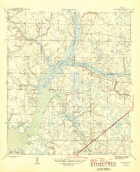
(9)- 1944 Map of Bayhead, 1967 Print
 1944 Bayhead1967 Print · USGSBay County's coastal lowlands and winding bayous are shown here during the mid-1940s, just as these waterfront communities were beginning to develop. Genealogists and historians can trace rail-and-water connections at Bayou George or locate early landings such as Mcallaster Landing.
 - 1945 Map of Bayhead
 1945 Bayhead1945 Print · USGSThe northern reaches of St Andrews Bay come to life in this mid-1940s survey of coastal Florida. Genealogists and researchers can trace the early layout of Bayou George, the stops along the St Andrews and Atlanta RR, and landings like Mc Allaster Landing.3 unique versions available
 - 1954 Map of Tallahassee, 1967 Print
 1954 Tallahassee1967 Print · USGSThe Florida Panhandle and South Georgia are captured here during a period of mid-century growth and military expansion. Researchers can trace the development of Panama City, the footprint of Tyndall Air Force Base, and the rail lines of the Atlantic Coast Line.4 unique versions available
 - 1959 Map of Tallahassee
 1959 Tallahassee1959 Print · USGSFlorida's Panhandle and the Big Bend region appear here in the mid-fifties, showing a landscape defined by its great river systems and developing coast. Trace the early layout of Panama City, the expansive Apalachicola National Forest, and the coastal St Marks Lighthouse.
 - 1960 Map of Tallahassee
 1960 Tallahassee1960 Print · USGSThe Florida Panhandle and southern Georgia are captured here in the mid-twentieth century, showing a region defined by its rivers and military installations. Genealogists and historians can trace the growth of Tallahassee or locate coastal landmarks like the St Marks Lighthouse and Tyndall Air Force Base.
 - 1981 Map of Panama City
 1981 Panama City1981 Print · USGSPanama City and the Florida Panhandle coast are captured here in the early eighties, showing the region's balance of military installations and maritime industry. Researchers can trace the Atlanta and St Andrews Bay RR or locate coastal sites like Tyndall Air Force Base and Dead Lake.2 unique versions available
 - 1982 Map of Bayhead, 1984 Print
 1982 Bayhead1984 Print · USGSThe northern reaches of the Deer Point Lake reservoir are captured here in the early 1980s, showcasing a growing network of coastal settlements. Researchers can locate family landmarks and early subdivisions like Bayhead, Camp Flowers, and the site of Hobbs Still.
 - 1988 Map of Tallahassee
 1988 Tallahassee1988 Print · USGSThe Florida Panhandle and South Georgia are captured here in the late eighties, showing the expansion of the regional highway network and coastal growth. Genealogists and historians can trace rail lines like the Seaboard System Railroad or locate family roots in Blountstown, Graceville, or Crawfordville.2 unique versions available
 - 2024 Map of Bayhead, 2024 Print
 2024 Bayhead2024 Print · USGSBay County's coastal bayous and expanding lakeside communities are captured here in the mid-2020s as residential growth meets the water's edge. Researchers can trace local heritage and land use near Deer Point Lake, from the Cedar Cem to the settlements of Bayhead and Majette.
End of results
Showing maps 1-9 of 9
Top cities near Bayhead
- Panama City historical maps
- Upper Grand Lagoon historical maps
- Lynn Haven historical maps
- Callaway historical maps
- Panama City Beach historical maps
- Springfield historical maps
See more
Frequently asked questions
- What are the different types of historical maps available for Bayhead?
- What is the oldest map of Bayhead?
- Where can I purchase historical maps of Bayhead for my home or office?
- Where can I download high-res historical maps of Bayhead?
- Are there historical topographic maps available for Bayhead?
- Is there historical aerial imagery available for Bayhead?
- Where are historical maps of Bayhead sourced from?