Old Maps of Cromanton, Florida
Explore 15 old maps of Cromanton, spanning from 1943 to today. These high-resolution historic maps reveal how streets, neighborhoods, landmarks, and natural features evolved over time — perfect for genealogy, metal detecting, research, and local history exploration.
What you can do with these maps:
- See how Cromanton changed over time: Compare historical maps to modern-day views to trace roads, homesites, rail lines & more.
- View detailed metadata: Each map includes creators, publishers, year, scale, and archive source.
- Overlay maps with satellite & LiDAR: Visualize the past alongside modern tools to explore terrain & human change.
- Trusted historical sources: Maps sourced from the USGS, Library of Congress, and other archives.
- Access maps your way: View online, download high-res files, or order prints for personal or research use.
Start exploring old maps of Cromanton to uncover forgotten places, hidden landmarks, and the deep history beneath your feet.
Cromanton, FL maps
(15)- 1943 Map of Beacon Beach
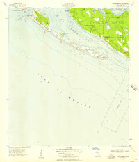
 1943 Beacon Beach1943 Print · USGSCoastal Florida in the early nineteen-forties reveals a landscape of isolated bayous and quiet shorelines before the postwar boom. Genealogists and local historians can trace the early layout of Beacon Beach and locate the Marywood Cem near Pearl Bayou.3 unique versions available
 - 1954 Map of Tallahassee, 1967 Print
 1954 Tallahassee1967 Print · USGSThe Florida Panhandle and South Georgia are captured here during a period of mid-century growth and military expansion. Researchers can trace the development of Panama City, the footprint of Tyndall Air Force Base, and the rail lines of the Atlantic Coast Line.4 unique versions available
 - 1956 Map of Beacon Beach, 1957 Print
 1956 Beacon Beach1957 Print · USGSCoastal Florida is captured during the mid-fifties at the height of military expansion along the gulf. Researchers can trace the layout of Cromanton, the grounds of Tyndall Air Force Base, and the small Marywood Cem near Pearl Bayou.2 unique versions available
 - 1959 Map of Tallahassee
 1959 Tallahassee1959 Print · USGSFlorida's Panhandle and the Big Bend region appear here in the mid-fifties, showing a landscape defined by its great river systems and developing coast. Trace the early layout of Panama City, the expansive Apalachicola National Forest, and the coastal St Marks Lighthouse.
 - 1960 Map of Tallahassee
 1960 Tallahassee1960 Print · USGSThe Florida Panhandle and southern Georgia are captured here in the mid-twentieth century, showing a region defined by its rivers and military installations. Genealogists and historians can trace the growth of Tallahassee or locate coastal landmarks like the St Marks Lighthouse and Tyndall Air Force Base.
 - 1981 Map of Panama City
 1981 Panama City1981 Print · USGSPanama City and the Florida Panhandle coast are captured here in the early eighties, showing the region's balance of military installations and maritime industry. Researchers can trace the Atlanta and St Andrews Bay RR or locate coastal sites like Tyndall Air Force Base and Dead Lake.2 unique versions available
 - 1982 Map of Beacon Beach, 1983 Print
 1982 Beacon Beach1983 Print · USGSThe Florida Panhandle's shifting barrier islands and military installations are captured here in the early eighties. Genealogists and historians can trace coastal changes near Cromanton, the grounds of Marywood Cem, and the reach of Tyndall Air Force Base.2 unique versions available
 - 1988 Map of Tallahassee
 1988 Tallahassee1988 Print · USGSThe Florida Panhandle and South Georgia are captured here in the late eighties, showing the expansion of the regional highway network and coastal growth. Genealogists and historians can trace rail lines like the Seaboard System Railroad or locate family roots in Blountstown, Graceville, or Crawfordville.2 unique versions available
 - 1994 Map of Beacon Beach, 1998 Print
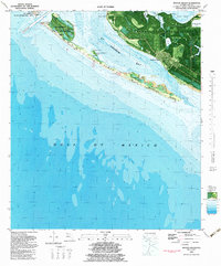
 1994 Beacon Beach1998 Print · USGSThe Florida coast near Panama City comes into focus during the mid-nineties as Tyndall Air Force Base and local beachfronts evolve. Researchers can locate Marywood Cem, the settlement of Cromanton, and the shifting sands of Shell Island.
 - 2012 Map of Beacon Beach, 2012 Print
 2012 Beacon Beach2012 Print · USGSCovers Cromanton, including Beacon Beach, Felix Lake, and other nearby areas
 - 2015 Map of Beacon Beach, 2015 Print
 2015 Beacon Beach2015 Print · USGSCovers Cromanton, including Beacon Beach, Felix Lake, and other nearby areas
 - 2018 Map of Beacon Beach, 2018 Print
 2018 Beacon Beach2018 Print · USGSCovers Cromanton, including Beacon Beach, Felix Lake, and other nearby areas
 - 2021 Map of Beacon Beach, 2021 Print
 2021 Beacon Beach2021 Print · USGSCovers Cromanton, including Beacon Beach, Felix Lake, and other nearby areas
 - 2024 Map of Beacon Beach, 2024 Print
 2024 Beacon Beach2024 Print · USGSCovers Cromanton, including Beacon Beach, Felix Lake, and other nearby areas
 - 2025 Map of Beacon Beach, 2025 Print
 2025 Beacon Beach2025 Print · USGSCoastal Florida's military and maritime landscape is on display in this contemporary look at the Saint Andrews Bay area. Military researchers and locals can trace the streets of Tyndall AFB, locate the Marywood Cem, or explore the shoreline near Cromanton and Shell Island.
End of results
Showing maps 1-15 of 15
Top cities near Cromanton
- Panama City historical maps
- Upper Grand Lagoon historical maps
- Lynn Haven historical maps
- Callaway historical maps
- Panama City Beach historical maps
- Springfield historical maps
See more
Frequently asked questions
- What are the different types of historical maps available for Cromanton?
- What is the oldest map of Cromanton?
- Where can I purchase historical maps of Cromanton for my home or office?
- Where can I download high-res historical maps of Cromanton?
- Are there historical topographic maps available for Cromanton?
- Is there historical aerial imagery available for Cromanton?
- Where are historical maps of Cromanton sourced from?