Old Maps of Econfina, Florida for Academic Research
Study the evolution of Econfina with 13 high-resolution historic maps. Whether you're teaching, researching, or modeling changes in land use, these maps provide essential visual documentation of urban, environmental, and geographic change.
- Analyze long-term change: Track patterns in development, transportation, and natural features.
- Ideal for environmental or urban studies: Support academic projects with primary historical map data.
- Use in the classroom or lab: Educators and researchers rely on these maps to bring historical context to life.
These maps are a powerful tool for teaching, research, and visualizing how Econfina has changed over the decades.
Econfina, FL maps
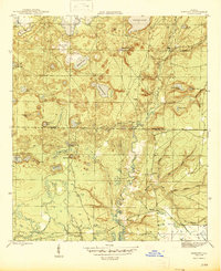
(13)- 1944 Map of Bennett, 1969 Print
 1944 Bennett1969 Print · USGSBay and Washington County during the mid-forties reveal a landscape of interconnected ponds and creek branches. Genealogists and local historians can trace family ties at Gainer Cem and Porter Cem or locate the rural settlement of Bennett.
 - 1945 Map of Bennett
 1945 Bennett1945 Print · USGSUpper Bay County and southern Washington County are shown here in the mid-1940s, centered on the complex drainage of the Econfina Creek valley. Genealogists can locate the Gainer Cem and trace old industrial sites like Mitchell Mill Creek near Bennett.3 unique versions available
 - 1954 Map of Tallahassee, 1967 Print
 1954 Tallahassee1967 Print · USGSThe Florida Panhandle and South Georgia are captured here during a period of mid-century growth and military expansion. Researchers can trace the development of Panama City, the footprint of Tyndall Air Force Base, and the rail lines of the Atlantic Coast Line.4 unique versions available
 - 1959 Map of Tallahassee
 1959 Tallahassee1959 Print · USGSFlorida's Panhandle and the Big Bend region appear here in the mid-fifties, showing a landscape defined by its great river systems and developing coast. Trace the early layout of Panama City, the expansive Apalachicola National Forest, and the coastal St Marks Lighthouse.
 - 1960 Map of Tallahassee
 1960 Tallahassee1960 Print · USGSThe Florida Panhandle and southern Georgia are captured here in the mid-twentieth century, showing a region defined by its rivers and military installations. Genealogists and historians can trace the growth of Tallahassee or locate coastal landmarks like the St Marks Lighthouse and Tyndall Air Force Base.
 - 1981 Map of Panama City
 1981 Panama City1981 Print · USGSPanama City and the Florida Panhandle coast are captured here in the early eighties, showing the region's balance of military installations and maritime industry. Researchers can trace the Atlanta and St Andrews Bay RR or locate coastal sites like Tyndall Air Force Base and Dead Lake.2 unique versions available
 - 1982 Map of Bennett, 1983 Print
 1982 Bennett1983 Print · USGSThe Florida Panhandle's spring-fed interior is captured here in the early eighties, documenting the rural landscape where Bay and Washington counties meet. Genealogists and historians can locate family sites like Watts-Gainer Cem and the settlement of Bennett.
 - 1988 Map of Tallahassee
 1988 Tallahassee1988 Print · USGSThe Florida Panhandle and South Georgia are captured here in the late eighties, showing the expansion of the regional highway network and coastal growth. Genealogists and historians can trace rail lines like the Seaboard System Railroad or locate family roots in Blountstown, Graceville, or Crawfordville.2 unique versions available
 - 2012 Map of Bennett, 2012 Print
 2012 Bennett2012 Print · USGSCovers Econfina, including Bennett, Bay County, and other nearby areas
 - 2015 Map of Bennett, 2015 Print
 2015 Bennett2015 Print · USGSCovers Econfina, including Bennett, Bay County, and other nearby areas
 - 2018 Map of Bennett, 2018 Print
 2018 Bennett2018 Print · USGSCovers Econfina, including Bennett, Bay County, and other nearby areas
 - 2021 Map of Bennett, 2021 Print
 2021 Bennett2021 Print · USGSCovers Econfina, including Bennett, Bay County, and other nearby areas
 - 2024 Map of Bennett, 2024 Print
 2024 Bennett2024 Print · USGSThe Florida Panhandle's river-cut lowlands and small settlements are documented here in recent years. Genealogists and researchers can trace lineage-named sites and burial grounds such as McQuagge - Harris Cem, Watts Gainer Cem, and the old settlement of Econfina.
End of results
Showing maps 1-13 of 13
Top cities near Econfina
- Panama City historical maps
- Lynn Haven historical maps
- Springfield historical maps
- Vernon historical maps
- Wausau historical maps
Frequently asked questions
- What are the different types of historical maps available for Econfina?
- What is the oldest map of Econfina?
- Where can I purchase historical maps of Econfina for my home or office?
- Where can I download high-res historical maps of Econfina?
- Are there historical topographic maps available for Econfina?
- Is there historical aerial imagery available for Econfina?
- Where are historical maps of Econfina sourced from?