1940s Maps of Bradford County, Florida
Explore 8 historic maps of Bradford County from the 1940s. These maps offer a rare glimpse into what life looked like during the 1940s — showing old roads, neighborhoods, homes, and landmarks that have changed or disappeared over time.
Whether you're researching your family's past, planning a metal detecting trip, or studying how Bradford County's landscape evolved across the 1940s, these high-resolution maps are a powerful tool for exploring the history of this region.
- Focus on a specific era: All maps on this page are from the 1940s, giving you a focused view of this time period.
- See what’s changed: Compare century-old streets, trails, and buildings to today's modern landscape using overlays and satellite layers.
- Research with precision: Use these maps for genealogy, historical research, land use analysis, or educational projects.
- View, download, or print: Maps are fully viewable online in high resolution, and can be downloaded or printed for your own records.
Start exploring Bradford County's history through authentic maps from the 1940s. This is your window into the past.
Bradford County, FL maps
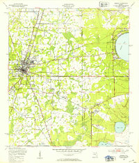
(8)- 1941 Map of Starke, 1942 Print
 1941 Starke1942 Print · USGSNorth Florida at the start of the 1940s reveals a region rapidly transforming with the mobilization for war. Genealogists and historians can trace old rail lines like the Seaboard Air Line and find communities like Sampson City or the expansive Camp Blanding Military Reservation.
 - 1943 Map of Hawthorn, 1963 Print
 1943 Hawthorn1963 Print · USGSAlachua County during the early war years reveals a landscape defined by its great lakes and a dual-railroad economy. Researchers can trace the routes of the Seaboard Air Line, locate rural landmarks like Ochwilla Church, or find family roots at Providence Cem and Drummond Cem.
 - 1948 Map of Starke
 1948 Starke1948 Print · USGSThe Florida lake country south of Starke is captured here shortly after the war, showing a landscape defined by citrus-era rail lines and massive military training grounds. Genealogists can trace family roots through settlements like Sampson City, Waldo, and the lakeside community of Keystone Heights.
 - 1949 Map of Sampson, 1953 Print
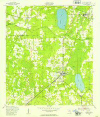
 1949 Sampson1953 Print · USGSFlorida's lake country in the late 1940s was a landscape of steam rail and rural schoolhouses. Genealogists can trace the location of homes near Sampson City Sta and local gathering places like Rising Sch or the Pine Level Ch.4 unique versions available
 - 1949 Map of Starke, 1953 Print
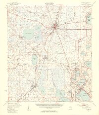
 1949 Starke1953 Print · USGSStarke and the surrounding Florida pine lands are captured here just after the war, showing the area's transition between agricultural life and new industrial and military uses. Genealogists and local historians can trace rural congregations at Bethel Ch and Nebo Ch or locate the early workings of the Trail Ridge Mine.4 unique versions available
 - 1949 Map of Waldo, 1953 Print
 1949 Waldo1953 Print · USGSAlachua and Bradford Counties are captured at a post-war peak of rail activity during the late 1940s. Genealogists and rail historians can trace the intersection of the Seaboard Air Line and Southern railroads through Waldo and Hampton.3 unique versions available
 - 1949 Map of Keystone Heights, 1953 Print
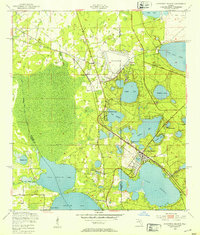 1949 Keystone Heights1953 Print · USGSFlorida's lake country is captured here in the years following World War II, showing the growth of Keystone Heights and its neighboring waters. Genealogists and researchers can trace the locations of the Brooklyn Sch, the Cem at Theressa, and the early layout of Tibbits Park Palms.4 unique versions available
 - 1949 Map of Starke, 1955 Print
 1949 Starke1955 Print · USGSNorth Florida at the mid-century reveals a landscape of lakeside settlements and vital rail junctions centered on Starke. Genealogists and historians can trace family roots through rural landmarks like Rising Sch, New Hope Ch, and the station at Sampson City Sta.2 unique versions available
End of results
Showing maps 1-8 of 8
Top cities of Bradford County
Frequently asked questions
- What are the different types of historical maps available for Bradford County?
- What is the oldest map of Bradford County?
- Where can I purchase historical maps of Bradford County for my home or office?
- Where can I download high-res historical maps of Bradford County?
- Are there historical topographic maps available for Bradford County?
- Is there historical aerial imagery available for Bradford County?
- Where are historical maps of Bradford County sourced from?