1970s Maps of Cape Canaveral, Brevard County
Explore 2 historic maps of Cape Canaveral from the 1970s. These maps offer a rare glimpse into what life looked like during the 1970s — showing old roads, neighborhoods, homes, and landmarks that have changed or disappeared over time.
Whether you're researching your family's past, planning a metal detecting trip, or studying how Cape Canaveral's landscape evolved across the 1970s, these high-resolution maps are a powerful tool for exploring the history of this region.
- Focus on a specific era: All maps on this page are from the 1970s, giving you a focused view of this time period.
- See what’s changed: Compare century-old streets, trails, and buildings to today's modern landscape using overlays and satellite layers.
- Research with precision: Use these maps for genealogy, historical research, land use analysis, or educational projects.
- View, download, or print: Maps are fully viewable online in high resolution, and can be downloaded or printed for your own records.
Start exploring Cape Canaveral's history through authentic maps from the 1970s. This is your window into the past.
Cape Canaveral, Brevard County maps
(2)- 1976 Map of Cape Canaveral
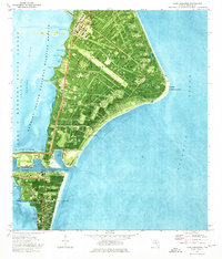 1976 Cape Canaveral1976 Print · USGSBrevard County's Atlantic coast is shown at the height of the Space Race era, revealing the intricate launch and tracking infrastructure of the Cape. Researchers can trace the layout of Port Canaveral, the Lighthouse, and historical sites like Indian Mound Cem.2 unique versions available
 - 1976 Map of Cocoa Beach, 1977 Print
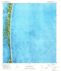 1976 Cocoa Beach1977 Print · USGSThe Space Coast shoreline was rapidly evolving during the mid-seventies, featuring dense coastal development and military presence. Researchers can trace canal developments in the Thousand Islands, the layout of Patrick Air Force Base, and landmarks like Canaveral Pier.2 unique versions available
End of results
Showing maps 1-2 of 2
Frequently asked questions
- What are the different types of historical maps available for Cape Canaveral?
- What is the oldest map of Cape Canaveral?
- Where can I purchase historical maps of Cape Canaveral for my home or office?
- Where can I download high-res historical maps of Cape Canaveral?
- Are there historical topographic maps available for Cape Canaveral?
- Is there historical aerial imagery available for Cape Canaveral?
- Where are historical maps of Cape Canaveral sourced from?