1940s Maps of Cocoa, Brevard County
Explore 4 historic maps of Cocoa from the 1940s. These maps offer a rare glimpse into what life looked like during the 1940s — showing old roads, neighborhoods, homes, and landmarks that have changed or disappeared over time.
Whether you're researching your family's past, planning a metal detecting trip, or studying how Cocoa's landscape evolved across the 1940s, these high-resolution maps are a powerful tool for exploring the history of this region.
- Focus on a specific era: All maps on this page are from the 1940s, giving you a focused view of this time period.
- See what’s changed: Compare century-old streets, trails, and buildings to today's modern landscape using overlays and satellite layers.
- Research with precision: Use these maps for genealogy, historical research, land use analysis, or educational projects.
- View, download, or print: Maps are fully viewable online in high resolution, and can be downloaded or printed for your own records.
Start exploring Cocoa's history through authentic maps from the 1940s. This is your window into the past.
Cocoa, Brevard County maps
(4)- 1949 Map of Courtenay, 1960 Print
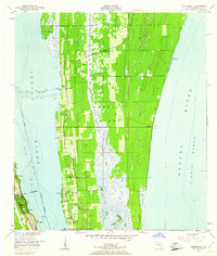 1949 Courtenay1960 Print · USGSMerritt Island and the Florida coast appear here just before the dawn of the space age, when citrus groves and river life defined the region. Researchers can trace early family sites at Courtenay and Indianola or locate historic landmarks like St Lukes Ch and Bethel Cem.3 unique versions available
 - 1949 Map of Eau Gallie, 1960 Print
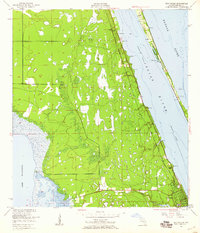 1949 Eau Gallie1960 Print · USGSThe Florida coast near the Indian River comes to life in the late 1940s, showing a landscape defined by its waterways and railways. Trace family history or local growth through labels for Eau Gallie, the Gleason Cem, and the Florida East Coast line.7 unique versions available
 - 1949 Map of Sharpes, 1962 Print
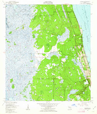 1949 Sharpes1962 Print · USGSBrevard County’s riverfront communities are captured here in the late 1940s, just as the coastal infrastructure was maturing along the Indian River. Researchers can trace early settlements like Frontenac, City Point, and Sharpes along the Florida East Coast rail corridor.6 unique versions available
 - 1949 Map of Cocoa, 1962 Print
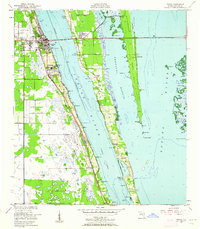 1949 Cocoa1962 Print · USGSThe Florida Space Coast appears in its pre-launch era, centered on the riverside towns of Cocoa and Rockledge. Researchers can trace the mid-century waterfront along the Indian River and explore early island settlements like Georgiana and Fairyland.2 unique versions available
End of results
Showing maps 1-4 of 4
Frequently asked questions
- What are the different types of historical maps available for Cocoa?
- What is the oldest map of Cocoa?
- Where can I purchase historical maps of Cocoa for my home or office?
- Where can I download high-res historical maps of Cocoa?
- Are there historical topographic maps available for Cocoa?
- Is there historical aerial imagery available for Cocoa?
- Where are historical maps of Cocoa sourced from?