1940s Maps of Titusville, Florida
Explore 3 historic maps of Titusville from the 1940s. These maps offer a rare glimpse into what life looked like during the 1940s — showing old roads, neighborhoods, homes, and landmarks that have changed or disappeared over time.
Whether you're researching your family's past, planning a metal detecting trip, or studying how Titusville's landscape evolved across the 1940s, these high-resolution maps are a powerful tool for exploring the history of this region.
- Focus on a specific era: All maps on this page are from the 1940s, giving you a focused view of this time period.
- See what’s changed: Compare century-old streets, trails, and buildings to today's modern landscape using overlays and satellite layers.
- Research with precision: Use these maps for genealogy, historical research, land use analysis, or educational projects.
- View, download, or print: Maps are fully viewable online in high resolution, and can be downloaded or printed for your own records.
Start exploring Titusville's history through authentic maps from the 1940s. This is your window into the past.
Titusville, FL maps
(3)- 1949 Map of Titusville, 1960 Print
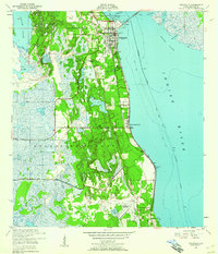 1949 Titusville1960 Print · USGSBrevard County’s riverfront comes alive in this late-1940s survey of the bustling rail and water hub of the Indian River. Genealogists and historians can trace the foundations of Titusville, locate the County Farm, and explore early aviation at the Titusville Cocoa Airport.6 unique versions available
 - 1949 Map of Mims, 1961 Print
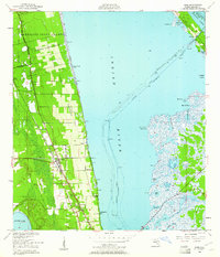 1949 Mims1961 Print · USGSCoastal Brevard County is captured in the late 1940s as the rail-side citrus and fishing communities of the Indian River thrived. Researchers can trace the layout of early Spanish land grants or find local landmarks like the Indian Mound, the community of La Grange, and the waterfront at Allenhurst.5 unique versions available
 - 1949 Map of Sharpes, 1962 Print
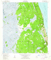 1949 Sharpes1962 Print · USGSBrevard County’s riverfront communities are captured here in the late 1940s, just as the coastal infrastructure was maturing along the Indian River. Researchers can trace early settlements like Frontenac, City Point, and Sharpes along the Florida East Coast rail corridor.6 unique versions available
End of results
Showing maps 1-3 of 3
Top cities near Titusville
- Merritt Island historical maps
- Cocoa historical maps
- Cape Canaveral historical maps
- Cocoa West historical maps
- Christmas historical maps
Top neighborhoods of Titusville
- Indian River City historical maps
- Whispering Hills Golf Estates historical maps
- Country Club Estates historical maps
Frequently asked questions
- What are the different types of historical maps available for Titusville?
- What is the oldest map of Titusville?
- Where can I purchase historical maps of Titusville for my home or office?
- Where can I download high-res historical maps of Titusville?
- Are there historical topographic maps available for Titusville?
- Is there historical aerial imagery available for Titusville?
- Where are historical maps of Titusville sourced from?